D-Rail
Take me through the city 龙轨
individualized mass-transit at hyper speed
Team D-rail: Neville Mars, Brice Bignami, Alex Beth Schapiro, Saskia Vendel, Burke Greenwood, Randall Winston
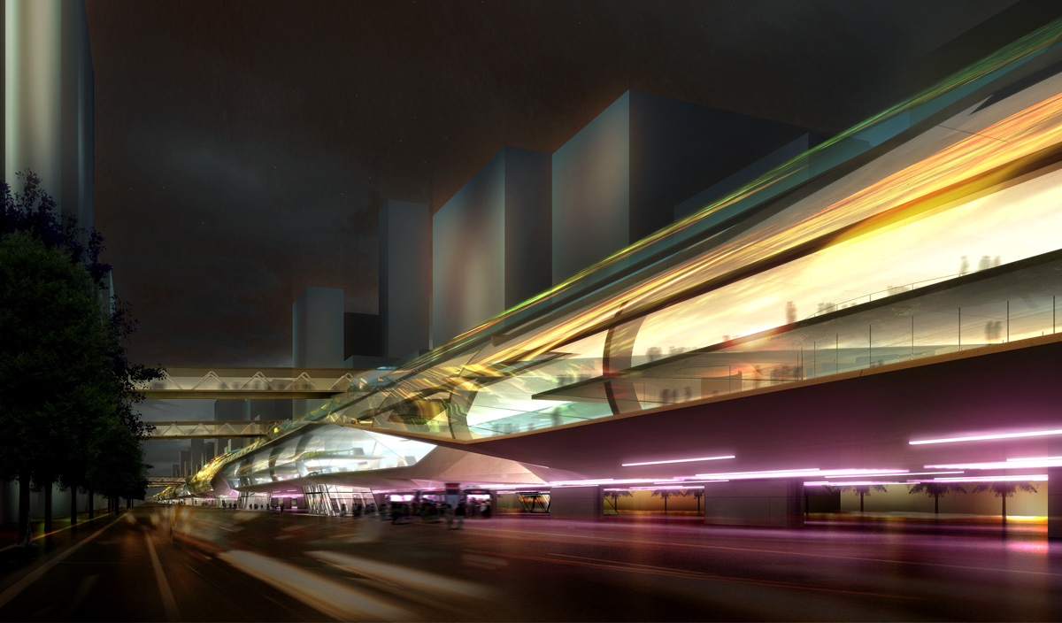
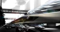
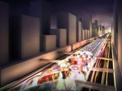
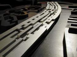
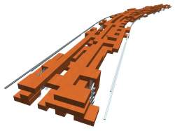
The D-rail is a hybrid form of high-speed pedestrian orientated mass transportation developed to curb Beijing's increasing struggle with congestion. The system combines travelators (flat escalators) with the Maglev (magnetic train) technology. In this innovative concept the trains never stop, so you never have to wait. There are no stations. Commuters can get on board at any point on the continuous loop around the 3rd and 4th Ring Roads of Beijing. This infrastructural insertion is an integrated part of a masterplan for Beijing. At the heart of the plan is a new center for the city of Beijing in 2020 developed by the DCF. Further reading about the proposal of the peri-center at Dynamic Density – Beijing's expansion and exclusion.
龙轨是高速人行道和公共交通的结合体,旨在缓解北京日益严重的交通拥堵问题。该系统结合了平面电梯和磁悬浮技术。在这新概念中,列车永不停下,所以你不需要等待。没有车站,乘客可以在三环和四环的任何一点自由上下。这一基建插件是北京总体规划的一部分,规划的核心部分是动态城市基金会为2020年的北京规划的新中心。这一公共交通解决方案则是与新中心和谐共生的。
XIAO KANG* ON THE MOVE
APPROACHES TO CITIES IN CHINA NEED TO BE BIG. THE SCALE AND SPEED OF CURRENT DEVELOPMENT PHAGOCYTOSES ALL OTHER METHODOLOGIES. INSUFFICIENT INTERVENTIONS ARE ENGULFED AND THEN DIGESTED. EVEN SMALLNESS NEEDS BIG PLAN PROTECTION. BEIJING HAS CEDED PROGRAMMATIC DEVELOPMENT TO THE MARKET: PRIVATE PROJECTS HAVE ATTAINED THE DIMENSIONS OF CITY MASTERPLANS, AND ARCHITECTURE HAS ABROGATED THE ROLE OF URBAN DESIGN. TRANSPORT INFRASTRUCTURE IS NOW THE FINAL ARENA FOR CITY WIDE PROPOSALS. THE CHINESE DREAM, AND THE CONTEMPORARY CHAOS, DEMAND VISIONARY THINKING.
CONDITIONS WITHIN BEIJING ARE EXIGENT. THE LAST 50 YEARS HAVE MADE THE CITY ENORMOUS. EXPANSIONS — PAST AND PRESENT — ARE DOMINATED BY MONOSPRAWL* AND INFRASPRAWL*, LEADING TO A FABRIC OF EXTREME COARSENESS. COMMUTES TYPICALLY REACH 2–3 HOURS. BUSES LACK COMFORT. TAXIS ARE IN THE SAME JAM. WHILE CONGESTION WASTES FUEL, DAMAGES PRODUCTIVITY, AND CONTRIBUTES MASSIVELY TO AIR POLLUTION (NOW 50% EXHAUST FUMES WITH CONCOMITANT ENVIRONMENTAL AND PUBLIC HEALTH COSTS), MOTORIZATION CONTINUES APACE. 1,000 NEW CARS ARE REGISTERED IN BEIJING EVERY DAY, AMOUNTING TO A 15% ANNUAL INCREASE ON A FLEET OF OVER 3 MILLION VEHICLES. THESE ARE ONLY THE REGISTERED ONES. ACCORDING TO OFFICIAL STATISTICS, TRANSIT BY PRIVATE CAR HAS RISEN FROM 6% OF TRIPS (1986) TO 23% OF TRIPS (2003). THIS LEAVES 77% YET TO BE MOTORIZED.
PUBLIC TRANSPORT LOSES ITS APPEAL IN A CONTEXT SLASHED BY ENORMOUS ROADS. COARSE BLOCKS EXAGGERATE DISTANCES, AND STATIONS BECOME INACCESSIBLE WHEN WRAPPED IN TWELVE LANE HIGHWAYS. THE STREET AS HUMAN-URBAN INTERFACE HAS BEEN WIPED: INSTEAD WE HAVE THE ROAD AS CAR THOROUGHFARE, AND THE ZEROING OF CHANCE ENCOUNTER. STANDING AT ANY POINT, BEIJING PRESENTS A SLEW OF NEUTERED VOLUMES — PLACES YOU CAN SEE BUT CANNOT GET TO. THE PEDESTRIAN ENVIRONMENT IS CHARACTERIZED BY GLOOMY TUNNELS, HIGH FOOTBRIDGES, WINDSWEPT EXPANSES OF BROKEN ASPHALT, LONG DARK STAIRWELLS, BLATANT NOISE, DIRTY AIR.
INFRASTRUCTURE CAN BE USED AS A TOOL TO COUNTER THE CITY’S MUD*-CREEP — THE CONTINUOUS OUTWARDS EXPANSION AND INNER CRUMBLING. GOVERNMENTAL POWER IN CHINA IS INCONTESTABLE, FACILITATING THE PURSUIT OF STEPPING STONE PROJECTS (E.G. THE OLYMPIC VILLAGE). THE CURRENT PLAN FOR BEIJING IS TO SLAP AN EXTENSIVE RAIL NETWORK (400KM OF NEW TRACK) ON TOP OF A BOOSTED YET ALREADY OVERSIZED ROAD NETWORK. THIS PRESENTS A UNIQUE AND EXTREME INFRASTRUCTURAL HYBRID. IT WILL HOWEVER PROVE NEFFECTIVE. THE PRODUCT OF SUPERIMPOSING UNINTEGRATED INFRASTRUCTURES IS TWO INCOMPATIBLE SYSTEMS WHICH ARE MUTUALLY INCAPABLE OF ALLEVIATING THE STRAIN THAT INADEQUACIES WITHIN EACH LAY UPON THE OTHER. YOU CANNOT OUT-ASPHALT A CAR TREND. YOU CANNOT RAIL PEOPLE INTO PUBLIC TRANSPORT WHEN THE PUBLIC REALM IS SO FRAGMENTED. NO ONE SOLUTION SUFFICES, AND THE VOLUME OF THE PROBLEM CANNOT BE DIVIDED UP AND METED OUT. BEIJING STANDS TO BECOME A CITY LADEN WITH TRANSPORT SYSTEMS, AND YET IMPOSSIBLE TO NAVIGATE.
THE QUESTION, ‘HOW CAN CONGESTION BE DEALT WITH?’ IS THE WRONG QUESTION. INSTEAD WE SHOULD ASK, ‘HOW WOULD WE LIKE TO TRAVEL?’ COMFORT IS NOT A LUXURY BUT A MEANS TO SHAPE CITY GROWTH. IN CHINA THE PRIVATE CAR CURRENTLY HAS THE STATUS, THE CONTROLLED INTERNAL ENVIRONMENT, AND THE INDIVIDUAL DIRIGIBILITY TO MAKE IT THE PREFERRED MODE OF TRANSPORT. INSTEAD OF CONGESTING PEOPLE OUT OF CARS — AT HUGE COST — A MORE ATTRACTIVE ALTERNATIVE MUST BE PRODUCED.
The D-rail is a big attempt to dramatically shrink the urban network
龙轨是大幅度缩小城市网络的大胆尝试
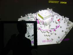
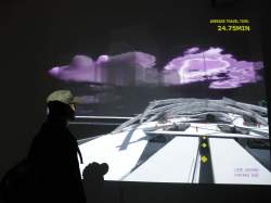
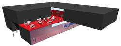
Beijing_REAL_TIME - description of the interactive installation
Can a never-stopping hyper-speed transportation system contain the sprawl of a ‘pancake city’ such as Beijing?
主题:一个永不停转的高速交通系统能否控制住像北京市这样的城市蔓延?
View the D_RAIL interactive installation video compilation
The Density profile of Beijing visualised: https://youtu.be/WKOeEHmmjys
D-rail / Beijing_REAL-TIME installation description PDF
Maps of Beijing cannot be made fast enough. The speed of its renewal defies any static representation. The city develops simultaneously outwards, inwards and upwards. It is planned meticulously yet seems to constantly elude planners' desires and objectives. The city follows its own agenda, changing shape, transporting densities according to its own account.
CONCEPT
Real-time Beijing investigates the consequences of planners' actions and address the question: Can this metropolitan monster be tamed?
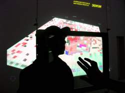
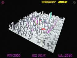
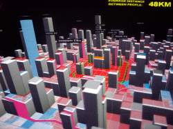
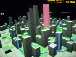
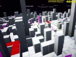
Users click on the map of Beijing to define the direction of its development. The objectives are obvious: clicking defines how the city’s 20 million people in 2020 are accommodated, where, how dense, grouped or dispersed. While playing this game of trial and error on the map, the result of your choices is projected on two walls as a cityscape of changing densities. The impossibility of a perfect city, the size and shape in relationship to its operation and efficiency become evident.
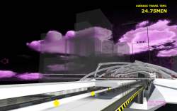
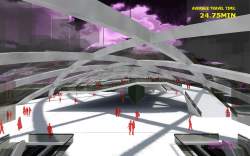
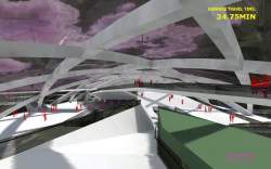
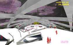
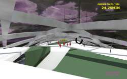
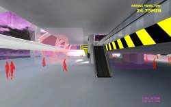
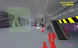
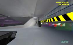
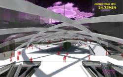
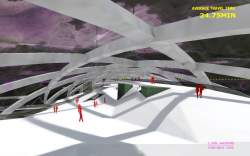
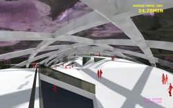
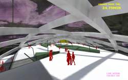
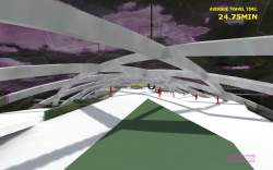
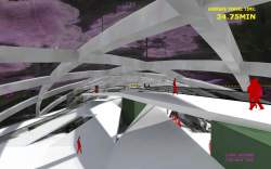
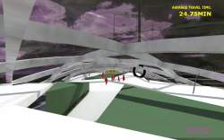
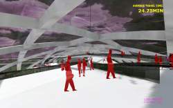
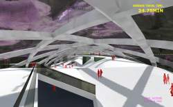
Transportation is the crucial aspect for a city’s efficiency and the one aspect directly affected by changing the layout of the city. Even mega-cities such as Tokyo can be served fairly effectively with public transportation. It's not the size of a city that matters, but the time it takes you to get somewhere. The DCF has made software that calculates a city’s efficiency based on average travel time. On the central wall BEIJING REAL_TIME you can view the effect of your planning choices projected as your SPEED going through the city. This speed can be experienced first hand as a virtually fly through Beijing and through our transportation system; The D-rail.
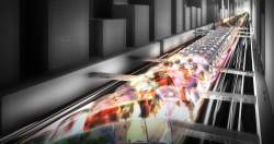
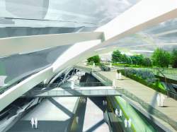
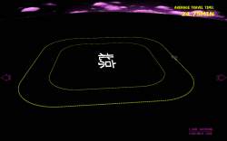
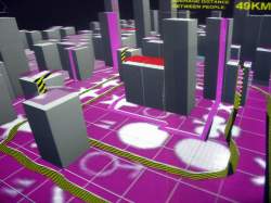
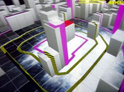
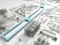
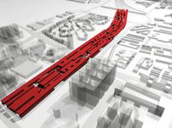
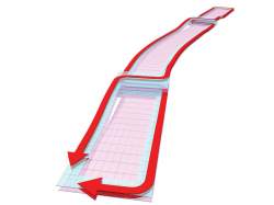
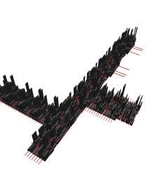
The D-rail is a design for an innovative mass-transit system that combines the speed of the maglev train with the efficiency of a travelator (flat escalator). In a 64 kilometer long ring the D-rail stretches all around Beijing’s Third and Fourth Ring Roads. People get on and off without the train ever stopping. This technology brings the commuter around the city in minutes. As your Beijing gets more efficient, the bigger does the D-rail grow and the faster is your navigation through the building and through the dynamic urban landscape. Enjoy the ride... !
Presented April 10, 2007 at the D.E.A.F. 07 in Rotterdam.
Goal:
When users touch the surface of the screen, they interact with the schematic map of Beijing. It's composed of a grid of 80x80 blocks, representing an area of 80X80 km of the Beijing proper – ie. the pancake.
Clicking these blocks makes them rise up or go down. The resulting shape is seen from a top perspective on the table, and its from 2 side views on the left and right walls. This shows the continuously changing density of the Chinese city.
Depending on the resulting morphology people create, on the front screen the building of the D-rail starts to take shape.
As users click on the map and change the shape, the city will get more or less efficient. Using a number of formulas from urban theory the program will assess the efficiency of each different state in the form of a rating. This rating can be read on the main screen as the ‘commuters average travel speed’.
目标:
当用户用手接触桌面的时候,他们接触的是由80*80个网格组成的北京地图,这些网格覆盖了北京的大部分区域。
点击这些网格就可以使他们升起来,升起的效果在桌面上是俯视的,但在左右两面墙上则是侧视的。他们显示了北京密度的动态变化效果。
根据这个效果,正面墙上开始显示D-rail。当人们点击地图和改变城市形状,城市的效率会随城市形状升高或降低。利用一些计算城市效率的公式程序能够判定各个状态中的城市效率,同时将其结果ADR(城市效率)显示在前方屏幕上。
通过点击地图,D-rail 建筑高度可以变化,通过城市效率可以控制行驶的速度。
The D-rail supports the peri-center* - the peri-center* supports the D-rail
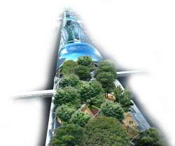
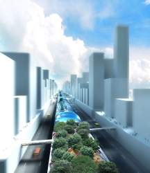
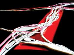
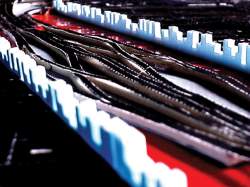
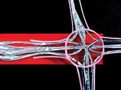
The 4th Ring Road becomes a massive four-level system that circumscribes the city. The top level contains the system’s central function and primary mode of transport: a Maglev train running in a continuous loop, giving access parity to all corners of the city. On the same level an uninterrupted park space belts the train whose landscape changes according to the city’s changing geography and architecture. This re-introduces a socially valuable public green space that, alongside the Maglev’s perfect flexibility for the pedestrian, crowns the system with an intensively pedestrian-oriented environment by bringing together commuters, strollers and shoppers alike.
The task is to reconcile two dynamically discordant forces: the unpredictable infrasprawl and monosprawl from the city center outward in every direction, and the stepping-stone, large-scale method of ordering & defining that marks Chinese planning. Rather than envisioning a synthesis of these realities as a solution, perhaps couched in some new age sort of dialectic with transportation authorities enacting ill-considered directives from the mount, our utopian infrastructure reconciles with a hammer.
The insertion of a seamless, all-location system along the 4th Ring Road with an open architecture gives the commuter a complete efficiency. This efficiency not only combines private and public spheres, but also allows for an organic growth that will encourage such intermingling as the system blends into the city's fabric.
D-rail version 0.1 - a system only based on travelators
D-Rail Bullet Points:
• A revolutionary transportation system giving unprecedented mobility.
• No stops. No changes. A system as localized as your own two feet.
• The world’s widest, longest and fastest trains. In 15 minutes traverse the 65 km 4th Ring Road at a standstill. Beijing just became local.
• Commuter flexibility on an unparalleled scale – over 10,000 access and exit ways on five levels leading directly into the heart of the city.
• 326 kilometers of continuous retail and commercial space. Shop ‘til you drop? Or while you move.-… more stats to go here….tarmac stats?
• The most technologically complex transportation system in the world – with a virtual ticketing and route-selection system that puts everything at your fingertips. Make mass transit your own.
• Current daily rush hour traffic: 11 hours, 2.5 million cars-worth of congestion, 1,000 cars added per day. D-Rail: all hours, no cars. All locations, no hassle.
• Over 6,500 square kilometers of constantly moving walkways. A system that never sleeps for commuters always on the move.
• A system for the people. Experience the Great Wall of transit – and keep barbarian cars out of the empire.
• Sustainable, affordable, universal. For 3 RMB and with no pollutants, frictionless trains serve the city’s millions in a matter of minutes.
• Constant mobility means constant connectivity and social exchange. Revolutionizing culture in new ways.
Intro on large infrastructural projects.
Abuse of power of large scale urban development projects and particularly the political significance of infra projects [to go with the Vicky crumbled ring roads diagrams]. The car and road lobby (introduced in DD) has left Beijing to struggle with the heritage of an inefficient urban texture that is oversaturated with tarmac … Unfortunately (as presented in DD) the amount of tarmac won’t solve the congestion problems Beijing is facing; complete gridlock seems inevitable... and building more roads will not solve the problem of hyper-congestion. …
(NOTES from DD: Beijing is in need of more living space and less congestion; two issues at the top of the agenda for any successful metropolis. Unlike most global cities it has unleashed a vast public and private effort to serve these needs and rebuild the city from scratch. The stepping stone* or mega projects have been completed; one in each corner of the city. For the near future – Beijing 2020 - a relentless scheme for urban renewal and mass-transit has been drawn up. For 2050 a subway grid larger than London should be in place. Since the conception of the ring road system a vast tarmac carpet has been patched together expanding still expanding in every direction. The sum of the two infrastructural ventures presents an entirely new and bizarre urban mechanical landscape that lacks the efficiency of a machine. )
Ie Beijing constitutes a unique and extreme infrastructure hybrid. The combined efforts of massive road systems (mostly in place) and a highly ambitious track based network (of subways and light-rail to be realized by 2020 and 2050) deliver a city that on paper is perfectly saturated with transport systems but remains horribly inefficient. What we’ve coined as coarseness* describes a fabric so stretched the infrastructure has generated more obstacles than offering connections – see infrasprawl*.
Even the goal to encourage pedestrian orientated transport becomes difficult when the actual stations require extraordinary effort to reach. This is exemplified by the countless gloomy tunnels and footbridges spanning the highways that cut through the city.
In addition the goal of decongesting the road systems has only a limited impact when the predominant amount of vehicles in a down town traffic jam are public vehicles such as busses and taxis. Instruments such as congestion tax that we expect to emerge in the center won’t solve the problem. The reality we foresee (based on Chinese statistics) is bus dominated transport making up as much as 80% of all commutes at least for the next two decades.
These factors one by one prohibit a common approach to mass-transit in Beijing. Considering the gravity of the congestion problems that can be expected in the year 2020 only an all-encompassing fully integrated high-end solution will suffice for Beijing’s transportation. At a time when Chinese planning is dominated by mega- (often megalomaniac) stepping stone* projects, the one aspect in urban planning that still allows and even demands an almost utopian progressiveness is large infrastructure.
The objective we have introduced to follow Beijing’s natural pancake-like growth pattern and move urban functions out as the only means to truly tackle down town congestion generates an opportunity to envision and create such an integrated infrastructural approach. Infrastructure is still the designated tool to give life to urban plans – this too applies to the peri-center*.
The opportunity to align transportation with real-estate development is not utopian. Public-private collaborations have resulted in subway and housing projects to be developed in perfect unison in China’s Special Administrative Region, Hong Kong. Nor are the cost of installing operating and maintaining high-end transit insurmountable if we compare them to the price of congestion today*.
• China is expected to surpass the US in car-ownership in 2020, yet it’s road systems wont be as generous as in North-America today. This means China should anticipate similar cost related to congestion. According to the TTI 2002 urban mobility study, in 2000 the total cost of congestion in terms of lost hours and wasted fuel was $68 billion. Nationwide, the total annual approaches a $100 billion per year.
o Source: Texas Transportation Institute, 2002 Urban Mobility Study:Mobility Issues and Measures, College Station, Texas 2002,
http://mobility.tamu.edu/ums/study/issues_measures/congested_roads.stm
BUS
Acknowledging the presence of a vast amount of tarmac and the central role the bus is likely to uphold for decades should for the basis of any integrated vision for the future of Beijing. Looking at London today the center is congested with busses. The relatively large footprint of the city draws in daily hordes of regional busses that cram together at the city’s key transfer nodes. This scenario is developing in Beijing. At the heart of the new circular center lies the Fourth Ring Road. Its massive surface* will be main street of Beijing’s new downtown area. In four layers it offers a continuous transit and retail zone absorbing all suburban cars and all suburban busses. The objective has been to reduce transfer times to the absolute minimum for passengers connecting to the trolley network serving the historic city.
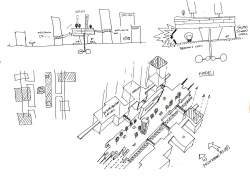
• First of all pedestrian - shrinking rings diagram to travelator diagram
• Access radius of different modes overlapping
• Full circle transport for equality between north and south of the 4th ring… calculations stop distance – speeds of maglev
• Single CHANGE SYSTEM … CATALYST
• Gondala busstop – for double deckers.
• Green belt reintroduced - park on roof connecting the private green bubbles of gated communities
• Growth … (through the clover leafs of the 4th ring road)
• Post-planning .. role of the 4th RR
• Open-architecture… internal public space network like Hong Kong … !
• Local streets / sidewalks elevated for denser center
• Dynamic social experience !
• Park – retail sandwich as public – private collaboration to create new peri-center
• D-rail: a mega-travelator built on MEGLEV hyper speed technology (diagram!)… a single connection.. .. no stops … color coding on floor for designated exits .. keep on walking …
• exit to transport side or to retails side …
Non-stop transit
…. Flex-bus ..can we elaborate ..
Hoods and moto-cars
V-rail – fully integrated system … ALEX
Non-stop system and fully integrated system …
The Sustainable City
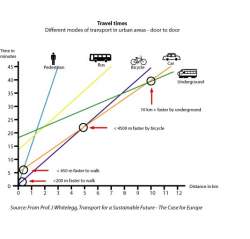
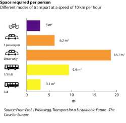
Travel Times and Space required per person
Updated section elevation sketch:
- Includes light-rail at highway level; thinning upper levels with large--->small spaces for economic diversity; more entry points, with interior & exterior walkways for upper-level spaces; sound-barrier acts as architectural feature.
Section elevation sketch:
Central bundle section elevation
Still reaching for light, vertical structure -- plus more interconnection & ways to infuse with surroundings!!!
NEW, innovative electric car model to be released in California later this year:
Mandatory low-emission or no-emission in MT Zone/D-Rail? And/or convenient electrical vehicle energy-outlets for motor-cars & cars along D-Rail?
Part of the Dynamic Density chapter
previously made diagrams for DD in pdf
DD-pdf of draft for dummy text + images
Central Bundle Structure
Sketch Pyramid diagrams
The D-Rail bundle will need to absorb / block sound from the 4th Ring Road away from the peri-center !
For the argument we need to overlay the position of the 4th RR on the sound pollution map > see green edge.
sketches D-rail version 2
A new suspended monorail coming to China:
http://www.apta.com/services/intnatl/intfocus/aer.cfm
Imagine a streamlined version attached to top level of the elevated central infrastructure -- light, thin, two-way, express; middle of 4th ring
More thoughts/ sketches soon on the overall central bundle design...
good images of monorail and pmt systems here http://www.skyloop.org/aerc/main.htm
Xinhua.net, the Chinese government newspaper states:
“In 2020 public transport will be the principal means of transit for residents in the Chinese capital, accounting for 50 percent of all city trips.”
-By 2007, the Beijing rail system is projected to expand by ten underground subways for an estimated 300 km of additional track.
-Additionally, several bus lines will be added the ever-expanding suburbs.
-More plans...tarmac expansion-underground highways-that without infrastructure, i.e. plug-in to D-rail, useless
Although all necessary, sincere efforts, these solutions, more subway, buses, and tarmac will only act a set of band aids for this gaping wound of endless congestion. Generalized commuter transit points, i.e. centralized nodes of transport, as a concept, are dead. Beijing mass transit needs an systematic change, an over-arching infrastructure to fit its new shape. Adjectives and exclamations aside, take a look at the following conservatively-arrived-at statistics:
-On average during peak commuter hours it takes two to three hours to cross the city.
-From 1986 to 2003, private vehicle usage has risen from 6 to 23.2 percent of all Beijing travels, while public transport usage has dropped from 35 to 26 percent. Every day Beijing has 1,000 newly registered cars.
-At a 15% annual increase, Beijing’s private vehicle number hovers around 3 million. This fleet accounts for half of the city’s air pollution.
Story lines for the new Mass Transit Zone
1. Central Bundle (CB)
- Elevated multi-level structure; light, open infrastructure on top of 4th ring road
- Buses, cars & individualized transport above ground; rail system underground
- Major artery of MT Zone
2. CB Localization
- Branching out in different modes to local areas
- Hoods act as transport nodes, intruded by travelators and widening the access radius to/from CB
- Possible Modes (see pyramid diagram):
Level 1: cars, buses, bikes, motorcars, individual transport modes (street level)
Level 2: cars, buses (elevated freeway level)
Level 3: motorcar/bike path, travelator (light transport level; levels from here on up branch out to
surrounding architecture/areas, connecting remote locales) etc...
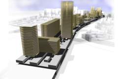
3. New Peri-center
- Magnet of MT Zone
- Likely location: north-east 4th ring road, above the flyover at Shoudujichang Expressway
- Massive, multi-tower mixed-use development on top of CB
- Open infrastructure -- allows for and encourages future growth of inter-connecting developments, opening the door for diverse, lively spaces around center
4. CB Hybrid System
- Relationship between people and the infrastructure -- open, well-structured and transparent: ease of choosing/using different types of transport throughout -- unintrusive system
- Systematics of the different modalities working together
- Product of Market-driven Organic Development: CB levels & modes of access are clearly delineated, yet allow for dynamic growth and inter-connection of surrounding areas
-Intro of 4th ring as a player and its importance
What is a reasonable distance to access public transportation?
--statistics of what the d-rail would need to be as a traditional stop-based rail system in ratio to successful, accessible mass transit: i.e. 198 stops, etc.
- And thus the revolutionary push to the continuous, all access rail…. and multi-layered infrastructure in one.
Owned by neville mars / Added by Mike Zhan / 17.6 years ago / 188862 hits / 20 hours view time
Backlinks
Tags
Latest Entries
-
Beijing_REAL-TIME D_rail screenshot
-
Neville Clean up this messy article
-
link to D-rail installation on you tube
-
Beijing_REAL-TIME.pdf
-
D-rail / Beijing_REAL-TIME installation description
-
D-rail birds-eye night green
Contribute
Login to post an entry to this node.