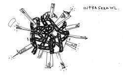
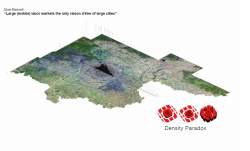
1.0 动态密度
动态密度
- Authors: Neville Mars, Saskia Vendel, Elaine Ho, Chang Liu, Yue Hongdan*, Shuengit
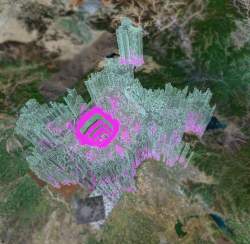
VIDEO of Dynamic Density software - part of the BEIJING_REAL-TIME interactive installation
DD-pdf of draft for dummy text + images
DD-pdf of diagrams ONLY
扩张与排斥
何新城
北京是件艺术品

这里讲述的是关于北京的故事,一个鲜活的城市,一个真实的故事,而非虚构的神话。北京沿袭了中国式城市发展的传统,而它彷徨在激烈的融合与对抗中却生机勃勃、活力四射则是个奇迹。奥运村、CBD和798的涌现让它更为传奇。它们不但成功提升了城市的形象,而且让北京成为全球经济文化论坛的平台;随时间的流逝,它们的影响力更将发扬光大。大山子艺术节已经美誉全城;然而曾为艺术、批判文化和草根创新的孵化器的798,已经死去。究其原因,或许是权力部门接管了这个自组织的社区,或许,798的死不过是财富流动、适者生存的自然结果。要探索北京发展之谜,我们有必要超越诸多形象工程、打破传统视角来仔细审视北京作为一个城市的发展进程。
城市路漫漫
城市是人类文明最伟大的创举。经过一万年,历经兴衰的城市俨然成为人类文明的框架,是文化与商业的温床。历史上的城市被规划、改造、再规划、再改造…… 城市总有它存在与发展的理由。今天,新技术的应用、新概念的引入让承载着不同历史的城市千姿百态。轨道交通、空港河港、后勤中心、隧道、高架桥、中心商务区、交通节点、科技园以及生态保护带等等带来了传统城市的新生(有时轻而易举、有时武力相加)。我们的家叠加而成了摩天大楼,道路扭结成完美的螺旋,工厂变成博物馆,建筑富于弹性,立面变得互动,购物活动室内化,历史街区被保护……随着城市空间的拓展和财富的增长,它们也越来越聪明,高科技被应用于复杂的交通指挥与灾害预防,关照社会与环境的福祉。
今天的城市是全球30亿人口的庇护所——这似乎是聪明的规划已经成功的最好明证。然而果真如此吗?假如让我们来设计一座完美的城市,它是该像纽约、东京、巴黎、开罗、圣保罗,还是像现代的北京呢?它会遭受严重的拥堵和污染吗?能否应所有公民的需要而建设城市,而不仅是生活殷实的一小撮呢?它应该随经济增长同步扩大,还是凝固下来、保持完美的形态和规模呢? 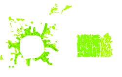
如果能梦见最理想的城市是什么就好了,如果能摸索出一步到位的完美城市发展模式就好了。在现实中,我们却无法逃脱规划总是落后于城市升级、扩张、增长以及蚕食的挣扎。当世界上大部分城市都由膨胀转为萎缩时,中国的城市化却截然相反。在这里,都市中人一次次试图逃离城市的喧嚣,却不断被汹涌的城市扩张浪潮所淹没。中国的城市化进程虽然落后于西方数十载,其追赶速度却相当惊人,与当初的“美国梦”很有一拼。中国的城市中心日益智能化,城市边缘的蔓延非常多样化,呈现出一派混杂的郊区发展势头。
动态城市
城市设计需要与时俱进,而中国的发展速度让所有的规划与设计都立刻过时。共产党当政10年后的1958年,北京市第一个总体规划出台了,目的在于遏制十年来经济飞速发展带来的城市膨胀,缓解城市资源和人口的压力。当时的解决方案是规划了40多个卫星城,并试图限制北京的城市人口。结果却不成功,尽管设限,城市人口却持续增长,卫星城的繁荣也从未实现。在此后的历次规划中,卫星城的数量则逐次减少,从23到14、11,而今天只有3个在旧县城基础上规划的卫星城对人口与投资还有些吸引力。与此同时,北京市的人口仍然有增无减,目前的数量比五十年前翻了四倍多。而日新月异的现实让城市规划的提案在出生之日即被现实抛弃。北京证明:在市场经济的框架下,用规划引导城市的发展方向其实相当困难。精心设计的街区、邻里、道路、公园等所谓理想组合不过是大而不当的简单堆砌。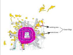
从零规划新城则更为困难。纵观历史,诸多增长爆炸期的国家都在寻找完美的城市发展模式。从早期的静态规划,到后来的点轴增长模型都是尝试的结果。在当代中国,“副中心”、“卫星城”、“新城”等都是相当有人气的模式,尽管诸如巴西利亚、马思和谷等新城规划却无不是失败的案例。究其原因,在现实中,城市的成功发展,城市环境的改善与城市的自我发展能力是息息相关的。这一自我发展能力正是让大都市聪明起来的源泉。也就是说,现代城市是个庞大的自我管理、供需互动的有机体,所有部分都按比例地整合在一起。如果我们铲除一个街区,一个更大的街区会出现;切断一条道路,替代的道路将出现;在某块土地上投资,当地的房租会上涨。作为有机体,城市是不可以被规划或设计的;即便可以,这样的规划或设计也不会是聪明的。对于一个打算在二十年内重新规划全部城市空间的国家来说,这一论断无疑是一剂苦药。
解剖城市
我们史无前例地近距离观察城市,探索、观察、测量并图表化它的一举一动。渐渐地,我们可以很有把握地确定城市独特的基因组成。建筑学范畴外的学者可以日益准确地预测城市未来的发展趋势。对于城市规划者而言,这些研究结果无疑是构思理性城市的辅助工具。但从根本上,他们仍然没有把城市当作一个有机体来对待。我们可以对城市进行功能分区,然后逐条街道,逐个街区地进行设计。但是这样仍然很难兼顾细节并准确预测结果。即便是解决城市交通拥堵的问题,也不可能脱离城市整个系统的运行来单独考虑。城市的各部分是紧密相连的。比如城市网格的大小与居住形式是紧密联系的,它们还会影响到城市的居住密度、交通的可达性以及居住与工作空间的分布等等。更重要的是,城市这种组分与组分之间的相关性并不是简单的线性关联,任何一个小小的动作都会牵一发而动全身,局部乃至整体的改变都意味着城市的重生。对于北京,我们则不禁要问,城市的变更究竟要深到什么程度才算城市的基因链发生了突变呢?
都市大改造
上世纪90年代关于城市的争论已告一段落,我们所面临的仍然是不可驯服的城市。尽管怎样驾驭这变幻莫测的城市仍无定论,但我们已经看到:无论是改造现有城市还是在城市的边界外开发新城都需要一些技术手段才能解决。如果大城市有自己的思想,那么处理这些问题的工具至少不该违背城市的意志,还应该对城市的发展有逐步的引导作用。新城也好,卫星城也好,它们作为城市改造的工具并不是一成不变的。它们的发展变化应该在一开始时就加以预测(例如曼哈顿从一片农田发展成为国际大都市)。
然而这种逻辑对于中国的城市并不适用,西方城市规划高度依赖人口普查和人口密度控制,并试图将规划对城市的影响降到最低点。与此截然相反的是,中国的城市转变是在强制规划的框架下发生的。这些强制规划往往不是脱离实际的宏观规划就是在旧城旁建设新城。例如,北京就同时存在着旧城重改造与新城开发这两种强制规划的模式。它们的并存则粗鲁地肢解了北京城——街道被拓宽,公寓和写字楼生硬地被嵌入,野蛮拼凑的城市结构取代了传统的秩序与优雅。城市的所有成分都在往“大”里发展,包括边界。这些不仅改变了北京的城市肌理,也让城市的功能明显异化:穿越马路的行人不能不望“街”兴叹。而城内的马路则把市中心分割成孤岛似的社区,个个被基础设施的巨墙所包围,真是雪上加霜。
现代的北京已经成了巨型街道、大型建筑以及形象工程的代名词。从空中俯瞰,北京是将历史文化中心层层包裹的现代化聚居环状带,中间是宽大的方格状居住小区(这种居住形式是北京城市形态的主要内容,也就是被称为“老北京”的象征,但在规划中,这种形式仍然极富争议)。五环之外,北京像张开的手指一样向外蔓延,郊区的高层住宅、别墅群、冒着黑烟的工厂参差错落,但这些并没有玷污北京的传奇色彩。尽管目标观众千差万别,北京的官方形象却带来了惊人的效率——比如吸引投资人/游客,让中产阶级开先河地成为私房拥有者,用发展和城市化的美好前景来安抚农民工等都有奇效。
里程碑式的规划、大规模标志性工程的嵌入往往是政府提高形象策略的核心招数。在亟需快速发展的巨大压力下,该策略的确让政府一切尽在掌握。然而,这一大跃进却存在着双重隐患。这些建筑单体往往挤占了城市规划的地位,规划的作用被完全忽略了。居住小区让公共空间私有化,道路系统被小区的围墙生生切断,只有一两个通往公路的出口。更严重的是,这些明星工程转移了人们应该将城市看成连续空间网络的视线,形象工程与北京的现实极不同步,而北京的传奇也与现实渐行渐远。
有关可达性
北京大爆炸
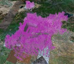
值得关注的是,在试图解决交通拥堵的北京“建桥运动”同时,基础设施的剧增与城市的破碎亦步亦趋。自上世纪80年代以来,紧凑的城市结构开始膨胀,并一发不可收拾地变形成了今天的“大饼”。城市中的一切在更为广阔的空间中进行重组和分配,分散成了片状的、相互隔离的“岛屿”。随着城市的爆炸性蔓延,居民却逐渐向城市边缘聚集。他们中既有主动追随郊区化大潮的中产及高产阶级,也有被动搬迁的流动人口——他们没有城市居民享有的权利,这一群体被迫从“老北京”的胡同迁至廉价的郊区。与美国的郊区化不同的是,这里不是连片的私家住宅,而是一个个无论贫富,都由显眼的高墙围合的居住群体。它们向一个个小的经济“中心”靠拢,它们的轨迹以及城市的边界也变得捉摸不定。成星状散射发展的北京在各个方向的蔓延已到达距市中心80公里的地方,而这个散射的城市边界(包括郊区)已经超过了6000公里。
 北京的通勤大军
到2020年,基础设施的扩张将有所缓解,向市场经济的转型激活了中国的劳动力市场。北京的城市结构也呈“蛙跳”式发展:原有的蜂窝式城市结构——“单位”,其工作与居住密不可分的城市格局迅速向郊区化、彻底分离的蜂窝式城市结构转变。于是日常通勤人流制造了该时段各种交通工具的严重拥堵。任何试图遏制交通拥堵和分散城市人口的举措都与制定这些举措的初衷——“加强联系!”自相矛盾。而城市的初衷又是什么?城市本该是加快交流、聚拢交易与合作的空间网络!
相对于日益增长的驾驶私车的通勤人士,道路必须相应地持续增加。按照现有的私车增长速度(每天1500辆),北京市应该每天增加10公里长的三车道公路。与此同时,轨道交通也应突飞猛进,让北京的交通变成由巨型公路网络与长里程轨道交通相结合的混合体。
公路和轨道交通的宏伟改造计划同时在进行,一个由中央政府规划,另一个则相对灵活,它们会让北京翻天覆地。但这些变化能解决日益严重的粗糙化与“北京大爆炸”日益碎片化的问题么?这其中的原因何在呢?如何在如此快速的增长之下去勾勒北京的城市边缘呢?简言之,我们该怎样去评价现代的大都市呢?
症状
在北京的日常生活中,城市的大部分地区是居民日常生活的盲点,很难够得着。如果你在东四环有一个公寓,那将意味着除非在周末或休假期间,你无法拜访住在丰台区的朋友。如果你打得起出租车,那么你得准备一早上都在车里度过。当然,公交车很便宜,但是慢得像乌龟而且极不舒适。无论交通系统多么复杂,衡量其效率的指标都可以简化为交通系统的可达性,即交通连接出发地与目的地之间的效率。城市系统的可达性,概括的说,取决于通勤时间的长短和通勤线路的长度。
虽然还处于婴儿期,交通拥堵问题却已是北京最严重的城市问题了,紧随其后的是空气污染。但如果我们审视北京最新的变化以及那些貌似很有激情的设计,我们就会看到,北京的堵不过是众多城市问题的症状之一而已。我们有必要探究交通拥堵的根本原因:这个城市与日俱增的不可到达性。
北京著名的环路,从二环到六环的总占地面积比紫禁城还大。简单地增加道路面积并不能缓解交通拥堵或增加可达性。北京的道路覆盖率并不及西方的平均水平,私家车的人均拥有量也不及。然而北京粗放式的城市结构意味着交通网络的节点极不可达,相对于舒适的私人汽车来说全无可比性。然而学者预测,公共汽车仍将是未来的主要交通方式。在数十年内, 80%的出行仍将依赖公共汽车。这一预测相当可信,因为越来越多的居住区在轨道交通还未到达的地方拔地而起,而大量的流动人口也将聚集在城市的边缘地带。
嵌入与收缩
文章的标题“扩张与排斥”说明北京城市空间的扩张和社会隔阂有直接的联系。机会不再均等,很多人都无法够及;空间的隔断更拉扯着财富的差距;有车族的社区围墙高筑,其中的生活单调而了无生趣;街道生活也不见踪影……这一切都在证明北京的命脉完全是为科技主义以及政治目标服务——为了提高道路的车流容积并保持城市的威望在疏导交通堵塞,而不是根本解决城市的不可达问题。官方的公共空间倒非常像模像样,整齐的围墙、严密的监视系统以及庞大的公园式景观。然而容易产生碰撞与摩擦的“小”空间才是城市存在的核心。北京的这种“小”却消失了,只剩下大型的封装式居住区和巨型基础设施的城市网格。而底层社会人群只能徘徊和思考在这些大型公共设施之间的缝隙。
我们还能让北京城重新紧凑起来吗?在保存内城的宽马路的条件下,要把北京带回到可以舒适步行的过去是不可想象的。无论将来对城市增长模式的探索可以如何精确,“分割”城市的发展之路,例如在郊区建新城等手段,将毫无疑问地恶化整个城市的通勤。此外就只剩下基础设施这一可以改造城市的唯一工具了。我构思了一个利用北京环路地面的精确嵌入式交通模型。当然,它很“大”。如果这让你有点意外的话,你更应该仔细读下去。中国并不缺少“大”的思路,也不缺少长远规划。但是和我们的出发点不同的是,中国对“大”项目的偏爱产生了拙劣的大型建筑和突兀的大型公共设施。我们恳请赋予城市更多细节的、多样化的、规模较小的建设项目,让它们来重新定义城市空间,复兴公共的互动空间。
我们研发了一个将步行速度提升到列车速度的混合交通系统--D-rail。这个系统结合了行人传送带和磁悬浮技术。在城市的环路上,高速运转的行人传送带在首尾相连的玻璃管道内不停运转,通勤者可以在环线的任何一点自由上下车,没有车站、不需等待。这个玻璃罩下的快速路就坐落在北京现有的环路上,三环可以建一个小型D-rail,四环可以建一个较大的叠加在现有的公路上,屋顶公园和零售商场则向两侧延伸。D-rail让高速公路变回人行道,它利用城市的无人区,将社区再次连接。这无疑是一次弥补城市裂缝、连接和多样化城市网格和急剧收缩城市膨胀的大胆尝试。
公共汽车、人口在城市中心的移动是交通堵塞的主要原因,而D-rail的功能则是吸收在市中心工作却居住在四环外的大量人口。D-rail的存在让四环上的公交车不再必要。再补以通往市中心的交通,行人能被更快地输送到四环沿线的任何地方。 D-rail每隔3分钟减速一次,减速时64公里长的磁轨上的门同时开启,人们被输送至相同速度的本地传送带,他们还可以选择通过电梯登上屋顶公园玩耍或下到商业街购物,北京的四环将因为D-rail的存在而魅力四射。
枢纽就是心脏
基础设施的确是改造现代大都市的有效方法,然而一个首都城市将如何接纳未来20年间新增的500到1000万人口呢?如果任何城市扩张都伴随着交通恶化,我们将怎样控制城市日益膨胀的规模和抑制它嚣张的增长欲望呢?
北京在2020年前的向外扩张不需要超过目前的30米,就足以为新增人口提供充足的驻留空间了。因为目前北京有6000公里的城市边界线,只要向外扩张一点点就够了。然而每个城市都有增长的趋势,北京的政府政策,虚假的、投机性质的投资更像激素一样刺激着生长。根据现有的规划和政策,到2030年,北京和天津之间广袤的农村地区将被新生的城市所填满。
我认为抑制北京扩张的最好办法就是沿D-rail激活它的内向型增长,从而限制其外向型的扩张。D-rail可以通过四环沿线的增长实现这一目标。如此一来,三环到五环之间的人口密度将会增加,向四环外搬迁的人将会被吸引回来,而住在历史文化中心的人也不必再迁出。相反,应该迁至四环外的倒是大量通勤的发源地——四百多座熙熙攘攘的政府大楼和研究机构。让城市功能搬出中心地带是限制高峰拥堵的最好办法。这样一来,城市的心脏不再是拥堵不堪的市中心,而是四环沿线,这个心脏的主动脉就是D-rail。
搬迁行政中心的提法并不新鲜,事实上它和卫星城的命运非常相似。当年梁思成试图保护历史文化遗产和古城的自然肌理,提出在古城之外另建现代化城市的时候,他上了黑名单。
现在时机已经成熟。四环已经拥有诸多住宅小区、中关村和CBD等大发展地带。D-rail能将这些分散的组团串起来。再加上交通枢纽和零售商业圈,每天有数百万的通勤人士在其间穿梭往来。顶层的公园让北京曾经在此规划的绿色生态带变成现实。搬迁的政府机关、博物馆、学校、科研机构等新建筑将完善该网络的关联性,从而让首都的心脏成为一个真正多样化的中心。
想象穿行在D-rail上,你可以便捷到达城市的任何地方,无所限制、无所障碍。徘徊于商店和酒吧,流连于宾馆大堂,穿梭于银行、办公楼之间……人们总是在安全舒适的室内,自由而惬意。这是一个将公共步行交通与楼房相连的高效步行王国。这在中国并非创举,香港已经有了一条很漂亮的步行传送通道。在通道中心加置D-rail倒是全新的理念,但它再适合北京的现实不过了。D-rail的嵌入像双搭桥手术外加新鲜肺叶移植,从此北京将拥有活力无比的心脏!
Neville Mars – 何新城
Summary
The city has its own logic. This is fortunate; it means we can try to understand it. And this is unfortunate; it means we can’t really control it. In the city the sum of all the meticulously planned neighborhoods and neatly designed urban expansion zones just renders a bigger amorphous beast. As it expands, it falls apart along its edges in ever more islands surrounded by more infrastructures. More highways that should connect the new elements to the city but simultaneously cut up the urban core and isolate these patches.This makes the city not only congested on the roads, but inaccessible for pedestrians and commuters in public transportation. Changing the constitution of Beijing is the only true solution to fight its congestion. But is that possible? The Dynamic Density chapter explores how to work with the will if the city, shifting densities in a natural direction to create a new center for an accessible Beijing.
城市有它自己的逻辑。这意味着我们可以试着去了解它;也意味着我们将无法控制它。在北京,所有谨慎规划的社区和整洁设计的新区加在一起不过是一块更大的饼。当它被摊得越来越大时,它会逐渐异化为一个个被基建设施包围的孤岛。越来越宽的高速公路分裂着城市中心。这不仅制造了交通拥堵,而且降低了行人与公交乘客的可达性。修改北京的法律似乎是解决交通拥挤的唯一方法。但是这可能吗?动态密度这一章探寻的是如何遵循城市本身的意愿,自然地调整城市密度,从而为一个可达性更强的北京创造一个新的中心。(full Chinese text available)
MONSTER METROPOLIS
FORMS WITHIN THE MODERN CITY ARTICULATE A COLLECTIVE INTELLIGENCE. SUCCESSIVE GENERATIONS OF DESIGN SOLUTIONS ARE REMAPPED ON TOP OF ONE ANOTHER WITHIN A CONTINUOUS CHANGE-RESPONSE-ADAPTATION CYCLE. AN EVOLUTIONARY PROCESS ENGENDERS THE NOTION OF AN ORGANIC FORCE. THE CITY BECOMES A “BEAST”: POWERFUL, DISAGGREGATED, INTRACTABLE, PERATING ACCORDING TO A LOGIC OF ITS OWN, AND WITHOUT REFERENCE TO AN OPERATOR. DISTRICTS BECOME ORGANS, HIGHWAYS ARTERIES, URBAN GROWTH THE EXPRESSION OF A DISTINCT AND MONSTROUS WILL. RAPIDLY THE URBANIST FINDS HIMSELF LOCKED IN BONDAGE TO HIS OWN CLICHÉ. EFFORTS TO TAME THE BEAST ARE REMEDIAL; OVERARCHING DESIGN IDEAS SUBJUGATED TO CONDITIONS IMPOSED BY A SOPHISTICATED METROPOLIS.
YET THIS MONSTER ANALOGY IS IN CHINA ESSENTIALLY PASSÉ.SHEER SPEED OF CHANGE HAS EFFECTED A RADICAL BREAK. CITIES ARE EITHER CREATED ANEW OR REBUILT UTTERLY. THERE CAN BE NO EVOLUTION TO FLASH DEVELOPMENT. INSTEAD A CORE PROFITMOTIVE DRIVES MULTIPLE HYBRID VENTURES IN THE PRODUCTION OF ONE-GENERATION-URBANISM. THE MASS INDIVIDUALIZATION OF SOCIETY, IN COMBINATION WITH FRESH OUT-OF-THE-PLASTIC MARKET MECHANICS, STRIPS THE PROCESS OF ANY SUPERIOR ORDERING PRINCIPLE. NEO-CORBUSIAN LANDSCAPES ARE BEING BUILT, BUT ON GROUNDS OF PRAGMATISM NOT IDEALISM. THOUGH DENSE, PROJECTS ARE PERFECTLY UNINTEGRATED, AND THE RATIONAL CITY IS NOT ACHIEVED. STATE CAPITALISM REPLACES SLOW EVOLUTION AS THE PRIMARY MANUFACTURER OF SPATIAL CONFIGURATIONS.
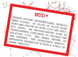
OPERATING UNCHECKED AND AT HYPERSPEED, SUPPLY IS NOT SUBJECT TO MATURE DEMAND. SPATIAL PRODUCTS COMPETE ON THE BASIS OF THE CITY THEY ARE SUPERSEDING (READ DEMOLISHING), NOT ON THE FUTURE CITY THEY ARE COLLECTIVELY CREATING. THE DESIGNER NOW WORKS ON THE LEVEL OF THE HYPER-METICULOUS — MICROPLANNING THE CHROME-FINISH ON THE BELLS OF 1,200 DOORS; THE WINDY ROAD WITHIN THE GATED COMPOUND — WHILE THE SUM OF THESE METICULOUSLY DESIGNED MOMENTS — I.E. THE SYSTEM ITSELF — REMAINS UNDESIGNED. INSTEAD THE CITY IS THE SPATIAL DERIVATIVE OF MARKET-DRIVEN UNINTENTIONAL EVELOPMENT:MUD*
MUD* IS CAPABLE OF PRODUCING URBAN FORMS FASTER THAN PLANNERS CAN MAP THEM, CITIES ABSORB THEM, OR CONSUMER-INHABITANTS REJECT THEM. MUD* FORMATIONS FOLLOW THE PATH OF LEAST RESISTANCE, PRODUCING AT CHINESE SPEED ESSENTIALLY STATIC REAL ESTATE PROJECTS. A SINGLE ITERATION OF THE BOOM-BUST CYCLE WITHIN CITY-BUILDING WILL HAVE LONG TERM CONSEQUENCES FOR CITY SHAPE AND PERFORMANCE. ULTIMATELY MUD* DEFINES THE FORM. FRAGMENTATION BECOMES THE ULTIMATE THREAT.
THE PURPOSE OF THE CITY IS TO FACILITATE DIRECT CONTACT BETWEEN LARGE NUMBERS OF PEOPLE. IF THE CITY CEASES TO REMAIN LINKED TO ITSELF, IT FAILS. A BODY WHICH OVERSEES THE WELFARE OF THE CITY AS A WHOLE, AND THE PROFITABILITY OF THE CITY AS A WHOLE, WILL NECESSARILY CONSIDER THIS ITS PRIMARY RESPONSIBILITY. THEREFORE ANY OVERARCHING THEORY MUST ADDRESS THE KEY ISSUE OF MAINTAINING FLOWS. THE ORGANIZATION OF DENSITIES THROUGHOUT THE URBAN REGION IS PIVOTAL TO THE EFFICIENCY OF TRIP PROCESSING AND TO THE SAFEGUARDING OF URBAN INTERACTIVITY. AT THE HEART OF COMPREHENSIVE URBAN DESIGN IS A METHODOLOGY FOR LOCATING DENSITIES INTELLIGENTLY.
MODERNISM EXHIBITS A DENSITY FETISH. CULTURAL CONSCIOUSNESS GRANTS IT A METROPOLITAN AURA. THE ICONOGRAPHY OF ADVANCED SOCIETY, LEANING CUPIDINOUSLY TOWARD SCIENCE FICTION, INVARIABLY ASSUMES ULTRA-DENSE STRUCTURES OF CLOSE-KNIT MATHEMATICAL BRILLIANCE, THROUGH WHICH INHABITANTS SURGE AS MULTITUDINOUS AS ELECTRONS. THE AVERAGE RESIDENTIAL CONSUMER HOWEVER, DESPISES DENSITY AND MOVES TO THE SUBURBS. HIGH DENSITY INTERVENTIONS WITHIN EXISTING CITY FABRIC OR SATELLITE SUPPORT TOWNS HAVE PROVED NOTORIOUSLY UNSUCCESSFUL. WHILE BOOSTING THE DENSITY OF PEOPLE PER SQUARE KILOMETER, THEY FREQUENTLY DIMINISH THE DENSITY OF SERVICES PER PERSON, AND VITIATE DIVERSITY. ANALYSIS OF PREVALENT URBAN DISTRIBUTION PATTERNS SUGGESTS A NORMATIVE DENSITY CURVE WITH TWO ESSENTIAL COMPONENTS. FIRST: HIGH PERFORMANCE DENSITY IS COMPOSED OF A CONTEXTUAL MATRIX OF DENSITIES, INCLUDING PEOPLE, PROGRAMMATIC MIX, AND FUNCTIONALITY. SECOND: DENSITY OCCURS WITHIN A TEMPORAL CONTINUUM OF URBAN EXPANSION AND SHIFTING DENSITIES. PLANNING DENSITY CANNOT BE REGARDED IN TERMS OF STATIC ACHIEVEMENTS, BUT INSTEAD MUST INCORPORATE AN UNDERSTANDING OF FLUID INTERACTIONS IN BOTH SPACE AND TIME: DYNAMIC DENSITY*.
DYNAMIC DENSITY* (DD) CONCEIVES OF AN OPTIMAL RELATIONSHIP BETWEEN FOOTPRINT AND POPULATION. URBAN EXPANSION PATTERNS ARE INTELLIGIBLE AND SHOULD CONFORM TO STAGE OF GROWTH MODELING. SCALES RUN FROM VILLAGE TO METROPOLIS, AND FROM RURAL TO URBAN ECONOMY. THE RESULTANT FRA MEWORK PROVIDES OBJECTIVES IN TERMS OF SIZE, SHAPE AND URBAN TEXTURE FOR DEVELOPMENTS ACROSS A WIDE REGIONAL NETWORK OF HIERARCHIES AND INTERDEPENDENCIES. THIS FACILITATES FUTURE PLANNING. IN PLACE OF REMEDIAL MEASURES (E.G. TRANSPORTING DENSITIES OUTWARDS), DD SERVES TO RENDER URBAN FLOWS MORE E HAT ANTICIPATE CONTINUOUS CHANGE EVEN AFTER COMPLETION
DENSITY — PROMOTING COMPACTNESS AS AN UNAMBIGUOUS DIRECTION TO COORDINATE All (CHINA’S) PLANNING EFFORTS.
DD* GOALS ARE FREQUENTLY UNATTAINABLE IN CITIES THAT HAVE FORMED UNDER SYSTEMS OF SLOW EVOLUTION. DEFENSIVE HISTORICAL IMPERATIVES HAVE FOCUSED MORE ON INCULCATING A POLITICIZED SENSE OF PLACE THAN ON INTEGRATING THE INEVITABILITY OF FLUX. THE SITUATION IN CHINA NOW IS DIFFERENT. DENSITY ITSELF IS IRRECUSABLE. POPULATION AND BUILDING DENSITIES ARE AMONG THE HIGHEST IN THE WORLD, AND MUD*- DEFINED INTERACTIONS PRODUCE NATURALLY COMPACT TYPOLOGIES. APPLYING DYNAMIC PLANNING LOGIC TO THE PHENOMENON OF MUD* OFFERS THE OPPORTUNITY TO HARNESS CHINA’S PREDILECTION FOR HIGH-RISE HIGH-SPEED DEVELOPMENT AND SET IT TOWARD THE PRODUCTION OF FUTURE-PROOFED CONFIGURATIONS. IN STARK OPPOSITION TO EVOLUTION’S MULTI-GENERATIONAL URBAN MONSTER, FOR WHOM THEORETICAL APPROACHES TO DENSITY ARE NOT BACKWARDS COMPATIBLE, IT BECOMES CONCEIVABLE TO BUILD CITIES WHICH ARE FORWARDS COMPATIBLE: URBAN STRUCTURES CREATED BY FLASH VENTURES, WHICH THROUGH AN UNDERSTANDING OF DD INCORPORATE WITHIN THEIR FABRIC THE POSSIBILITY FOR FUTURE ADAPTATION. IMMEDIATE INSTANTIATIONS OF MUD* FORMS CAN BE HARSH, BUT ANTICIPATE FURTHER CHANGE. READ-RESPOND OPERATIONS ARE PERFORMED AFTER THE FACT OF CONSTRUCTION, BUT UPON LAYOUTS WHICH ENVISAGE SUBSEQUENT EVOLUTIONS. WHAT TRADITIONALLY HAS BEEN PATCHWORK BECOMES REFINEMENT. WHAT INITIALLY APPEARS TO BE BRUTALLY INORGANIC BECOMES HUMANIZED AND COLORIZED. THE SHEER THRUST OF HIGH-SPEED URBANIZATION BECOMES A MEANS TO SURPASS THE NATURALLY MONSTROUS CITY. DD MAKES THE MONSTER WORK FOR YOU.
DCF PREMISE
Urban density is physical and has a geographical location
urban density has shape, and a trait of dispersion
Density is the result of its context and it generates a context
DENSITY DYNAMICS ARE TRACEABLE
It has a sped and a direction
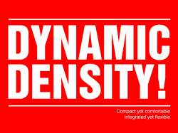
# Density is Dynamic!
DD MODEL
DYNAMIC QUALITIES REQUIRE FLEXIBLE PLANNING SOLUTIONS
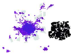
SPACES PRODUCED UNDER CURRENT CHINESE HYPERSPEED ARE STATIC
COLLECTED TOGETHER THESE FORMS RESULT IN MUD*
HYPERSPEED DEVELOPMENT WHICH ANTICIPATES CHANGE CAN LEAPFROG
MUD* — ABNEGATE PATCHES — INCORPORATE DYNAMIC DENSITIES
# compact yet comfortable integrated yet flexible
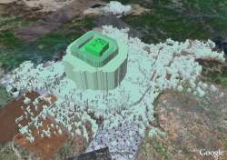
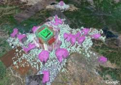
CASE BEIJING: DD RE-ENGINEERS THE CAPITAL
--
EXPLODING BEIJING: ACCELERATING FRINGE / DISINTEGRATEDCENTER
MAPS OF BEIJING CANNOT BE MADE FAST ENOUGH. THE SPEED OF RENEWAL DEFIES ANY STATIC REPRESENTATION. EVEN A PERFECT
DATASHOT FROM SPACE WOULD BARELY CAPTURE THE REALITY OF A CITY IN TRANSITION. GROWTH BECOMES STEP-CHANGE IN THE CONTEXT OF JUDDERING POLICY SHIFTS AND AN ENVELOPE OF EXTREME TIME COMPRESSION. THE CITY LEAPS IMULTANEOUSLY
OUTWARDS, INWARDS AND UPWARDS. WHILE THE GOAL IS COMPLETE METAMORPHOSIS, IN REALITY THIS IS NEVER ACHIEVED. EVEN A CLEAR UNDERSTANDING ABOUT WHAT SHAPES WILL EMERGE REMAINS ABSENT.
IMPACTS UPON URBAN SOCIETY ARE NO LESS RAMPANT OR CAPRICIOUS. FURIOUS OUTBREAKS OF THE NEW CITY THREATEN TO CHOKE THE WHOLE, OR DERACINATE IT ALTOGETHER FROM ITS OWN SENSE OF PAST AND PLACE. OPULENT CEILINGS RAISE CHANDELIERS FROM THE RUBBLE. MIGRANTS PICK OUT BRICKS FOR THEIR OWN MAKESHIFT VILLAGES. A BALLOONING POPULATION OF XIAO KANG* AND INTERNATIONAL URBANITES RUSH TOWARD THE NEW DOWNTOWN NODES OF WORK, LIFE, AND LEISURE. AT THE SAME TIME LOCALS ARE BEING SWEPT UP AND RELEASED OUT IN THE SUBURBS. THE TWO GROUPS GLANCE AT EACH OTHER AS THEY CROSS UNDER THE SHADOW OF A WRECKING BALL.
THE NEW URBAN FABRIC IS DENSE, YET COMMANDEERS AT ONE END WIDE TRACTS OF ARABLE LAND; AT THE OTHER EATS INTO THE HISTORIC HEART. STARCHITECT MEGAPROJECTS ARE CONCEIVED AND INSERTED AT DESIGNATED POINTS TO PROJECT THE IMAGE OF THE CAPITAL CITY OF A FUTURE SUPERPOWER. MULTILANE HIGHWAYS LACERATE THE CENTER. CUT-OFF TISSUE IN BETWEEN IS THROWN OUT IN CHUNKS TO THE MOST RAPACIOUS OF ACTORS WITHIN A STILL TEETHING REAL ESTATE MARKET. ALL ALONG THE URBAN FRINGE, WAVE AFTER WAVE OF RESIDENTIAL MEGABLOCKS, GIVE RISE TO ENTIRELY NEW SUB-CITIES. THE COMBINED PRODUCT IS AN EXPLODING BEIJING: ONE FRAGMENTING OUTWARDS WHILE DISINTEGRATING AT THE CORE.
THE CONCENTRATIONS OF URGES AND OUTBURSTS — GLITZ, SHANTY TOWNS, WALL STREETS, MODERN AMENITIES, NEON, LUXURY, STREET VENDORS, OLD STYLE MAOISTS ETC. — IS AS BEWILDERING AS THEIR FRACTURED SOCIO-SPATIAL INTER-RELATIONS. EXCLUSION IS EVERYWHERE AND OF EVERYTHING (PEOPLE, WEALTH, POLICY IMPLEMENTATION, RULE OF LAW), AND DIVISIONS APPEAR WITH THE SAME HARSHNESS AND IMMEDIACY AS ALTERATIONS TO THE STAGGERED SKYLINE.
CRITICISM BOTH FROM OFFICIALS AND CITIZENS FOCUSES ON SEVERE CONGESTION AND RISING REAL ESTATE PRICES. BUT WITH CHINA’S CONTINUING RECORD-BREAKING LEVELS OF INVESTMENT AND TOTAL LOVE FOR THE MOTOR CAR, THERE IS LITTLE TO SUGGEST ALLEVIATION ON EITHER FRONT. UNABASHED, LOCAL PLANNING DEPARTMENTS CONTINUE TO OK (READ PARTNER) EVER MORE STRATIFIED AND DISPARATE PROJECTS.
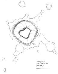
AT THE HEART OF BEIJING’S CURRENT CONTRADICTIONS AND SNAP RELOCATIONS IS THE FRAUGHT SHIFT FROM MONOCENTRIC RING CITY TO POLYCENTRIC MULTICITY. SHANGHAI HAS PURSUED A POWERFUL SATELLITE MODEL; THE PEARL RIVER DELTA AN OPEN MARKET REGIONAL NETWORK. BEIJING IS AT THE HEIGHT OF ITS AMBIGUITY AND BLUR. AS SUCH, IN THE MIDST OF PERIPHERAL BALLOONINGS, COARSE UPSCALING, CONGESTION TO THE POINT OF DYSFUNCTIONALITY, HAZE, AND BLATANT SPEED, IT IS THE ESSENTIAL CASE STUDY FOR DD.
BEIJING: PORTRAIT OF A CITY 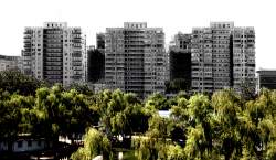
BEIJING IS MUCH BIGGER THAN YOU THINK, AND EXPANDING MUCH FASTER THAN OFFICIALS ADMIT. THE DEFAULT WESTERN VERDICT IS THAT IT SPRAWLS. BUT SPRAWL IS A TERM FREQUENTLY BANDIED, YET SELDOM SUBSTANTIATED WITH A DEFINITION. IT HAS BECOME A CATCH-ALL PEJORATIVE FOR UNWELCOME URBAN EXPANSION.
IN ONE SENSE THERE IS IN FACT NO SPRAWL IN THE CHINESE URBAN CONTEXT. BEIJING SITS AT ONE END OF THE LARGER ETROPOLITAN FIELD OF JING HU* — A CONTINUOUS (SEMI-)URBANIZED REGION WITH AN AVERAGE DENSITY OF 944P/KM2. THIS FIGURE IS OMPARABLE WITH A MEDIUM-SIZED AMERICAN CITY. ON THE LEVEL OF PURE DENSITY, JING HU* IS SPRAWL FREE.
HOWEVER, ANALYSIS OF BEIJING REVEALS A NUMBER OF NEW FORMS WITH DISTINCT QUALITIES, SOME OF WHICH IMPACT NEGATIVELY UPON THE URBAN DYNAMIC. PASSING FROM THE HISTORIC CENTER (THE BLACK HOLE) OUT THROUGH THE SURROUNDING URBAN CORE (THE PERICENTER) INTO THE RURBANIZING FRINGE (THE GREEN EDGE) AND THE WIDER FIELD OF GRAVITY, WE HAVE IDENTIFIED THESE FORMS AND EVALUATED THEM AGAINST THE ESSENTIAL CRITERION OF CITY ACCESSIBILITY. A –SPRAWL SUFFIX IS USED TO INDICATE RISK.
Sprawl has become a catch-all pejorative for unwelcome urban expansion. DCF sprawl derivatives describe and evaluate specific characteristics of that expansion which impact negatively upon accessibility.
‘摊大饼’已经成了一切不受欢迎的城市发展的总称. 我们这里所说的’摊大饼’指的是会影响到可达性的那些城市蔓延.
1. BEIJING: RING BY RING — A TYPOLOGICAL SECTION
BEIJING IS A CITY DOMINATED-DEFINED-DIVIDED-CONNNECTED- SERVICED- NAVIGATED-RATIONALIZED AND MOST COMMONLY DESCRIBED BY ITS RING ROADS.
THE CONCEPT FOR A RING AND RADIAL SYSTEM CAME INTO EXISTENCE IN THE 1950S, AND CLEARANCE WORK STARTED IN 1965. HOWEVER, THE CONTINUOUS BELT HIGHWAYS OF TODAY HAVE ALL BEEN COMPLETED DURING THE POST-REFORM ERA. PLANNING STRATEGIES PREDICTED THAT THE FOURTH RING ROAD WOULD SERVE AS THE EDGE OF THE CITY CENTER, THE FIFTH LINK SUBCENTERS,
AND THE SIXTH CONNECT SATELLITE TOWNS. REALITY QUICKLY OVERRAN THE SKETCHES. BY 2007 THE CITY CENTER SPILT WELL BEYOND THE FIFTH RING ROAD IN ALL DIRECTIONS.
BEIJINGERS TALK RINGS ABOUT THEIR CITY TO TELL EACH OTHER WHERE THEY ARE (”NEAR THE NORTH THIRD RING ROAD”, ”BETWEEN WEST THIRD AND FOURTH” ETC.). THE RINGS ALSO MAP THE TYPOLOGICAL AND POLITICAL HISTORY OF THE CITY.
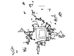
![]()
The First Ring Road
At the centre of historic Beijing lies the Forbidden City, itself encircled by the Imperial City (a collection of lakes and parks), in turn set within the old inner and outer city. A defensive city wall (now the Second Ring Road) once girt this basic structure of an annulus of citizen dwellings round the preserve of the emperor. The origins of Beijing’s ring-based transit system lie in the 1920s, when a 17km ring tram line was constructed to connect key points throughout the non-imperial wall-bound area. The disassembly of the tram lines in the 1950s reduced this once clearly defined route to a collection of road surfaces. Gradually these ceased to carry any special significance. Nowadays, the First Ring is little more than a question: ”What is it? Where did it go?”
Within the Second Ring Road
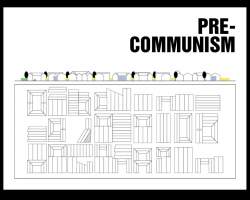
SECOND RING ROAD: 32km long; 1.4km2 surface area
Central Beijing is still dominated by hutongs*. A clear grid of major avenues demarcate cellular congregations of tight single story dwellings, themselves clustered around courtyards and along roads barely wide enough for a single car to pass. Historically this structure indicated celestial order; today it forces the bulk of traffic down a limited number of invariably busy intercellular arteries.
The cultural and indeed economic value of the hutongs* is a source of no little controversy. Inhabitations are mostly cramped and basic, with many homes relying on communal toilets for elementary sanitation. However, the hutongs* carry an undeniable social quality, and provide the essential context for the city’s historic sites and traditional identity. Bulldozing and redevelopment, dating from in the 1990s, has eaten away large patches of the old fabric. A new wave of interest, inspired in part by cultural heritage foundations, but also by monied foreigners seeking a more “Chinese” environment, has recently rehabilitated the value of the courtyard home. However, although large parts of the center are now officially protected from demolition, renovation-restoration-mod-con makeover projects are pursued without sensitive regulation, and rapid and often crude transformation of the historic environment continues.
Second to Third Ring Road
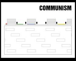
THIRD RING ROAD: 48km long; 2.9km2 surface area
The Maoist reconditioning of old Beijing maintained the cellular principle but redrew the cells, this time carving the city into separate units controlled by different danwei*. Each danwei* integrated home, work and leisure within the confines of the cell, thus negating the need for commutes. However the units themselves expanded, directed by their own individual needs and ambitions, and with little regard for overall city form. Development was frequently land-inefficient and uncoordinated. At the same time that the carinspired American consumer was driving out past the urban periphery to build a new suburbia, China too, under a productionist logic, was pushing beyond its city-boundaries. Ironically before cars or roads were introduced on any major scale, Beijing already found itself encircled by suburbs. A single housing typology was deployed: six story soviet-style walk-ups, all facing south.
Third to Fourth Ring Road
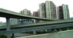
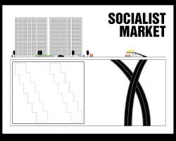
FOURTH RING ROAD: 65km long; 4.7km2 surface area
The reforms which started in 1978 marked a new era for Beijing — one of land values, investment in infrastructure, and real estate projects. Beijing’s already distended spatial configuration fueled big road thinking. The new highways of the 1980s, including the Second and Third Ring Roads, lashed Beijing with asphalt. The nascent development market responded with highway tower mass housing: slabs, crosses and hash shaped extrusions*, footed on large roads, reaching 25 stories, and wholly car-dependent. The dramatic upscaling of both building and street resulted in a new urban coarseness.
Fourth to Fifth Ring Roads
FIFTH RING ROAD: 98km long; 5.5km2 surface area
The sudden rise of Beijing’s super rich, in conjunction with the emergence of profit-driven development opportunities, rapidly led to a bevy of luxury residential compounds. These bear many of the same features as their predecessors (from danwei* blocks to highway towers) — cellularity, non-integration, homogeneity and essential monolithicism — and yet the pronouncement of these qualities in the young market context is that much harsher. The compounds’ walls and guards reinforce economic disparities with physical divides. The building process is one of seal and sear, by which a single block is fenced off, scorched of all previous qualities, and an international luxury imaginary is imported and materialized on site.
Lying at some distance from central Beijing, these exclusive gated communities, with their idiosyncratic reinterpretations of the Eurovilla or the Chinese watergarden (though never so traditional as to forget several generous carports), lay value claims to American suburban lifestyle, yet
further stress the already ailing transit arteries.
Fifth to Sixth Ring Road
SIXTH RING ROAD: 190km long; 13.8km2 surface area
Beijing’s relentless onslaught into itself — razing old neighborhoods to erect new build — throws both tissue and residents outwards. Mass redevelopment of the old city creates a reverse stream of former locals in need of new housing. Equally, new wealth and opportunities draw waves of migrants, and generate ad hoc program in cheaper locations. Beyond the Fifth Ring Road, among starkly delineated compounds and the slow concrete curves of elevated highways, mass creations of affordable housing unexpectedly arise. Monofunctional program quickly generates a bottom up response. Entrepreneurial zeal and obscure regulatory environments provide a fecund base for informal villages, which quickly emerge to service enormous underplanned developments, each housing thousands of people, and yet providing little else. As the perimeter of the city keeps creeping outwards, former villages are engulfed, and all along the rurbanized fringe buildings suddenly start gaining stories. Within the spreading mass, temporary pockets appear — worker enclaves specific to construction sites; brief floating villages* inside the restlessly shifting city.
Beyond the Sixth Ring Road
As Beijing’s formal expansions bleed into booming villages (themselves upscaling) and bustling factories (with significant worker populations compounded on site), the question arises as to where the city actually stops so as to define where it can be stopped. The influence of the capital is still apparent, with new roads being built and logistics networks developed. But at this remove the gravitational force exerted on the commuter by the center is weak.
Itentionally and unintentionally Beijing is moving away from the monycentric city model
无论是否有意识,北京正与单中心的城市模式渐行渐远规模的房地产项目则不断将小规模的自发性开发推向边缘地带.
2. BEIJING: HOME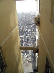
BEIJING HAS LONG SOUGHT TO DECONGEST THE CENTER BY MOVING PEOPLE OUT. LAND REFORM HAS BEEN USED AS A TOOL TO FACILITATE THIS PROCESS. THE CHIEF PRODUCTS HAVE BEEN MASSIVE DEVELOPMENTS WHICH STRETCH THE PERIPHERY, AND THE LOSS OF DOWNTOWN IDENTITY.
--
MOVERS AND SHAKERS (FROM RENOVATION TO RELOCATION)
Unlike say New York or New Orleans, New Beijing is being built right where Old Beijing used to be. There was a city there already when they started, and as a result, the much-vaunted building boom of the last decades has equally been a demolition boom. Whole sections of the former city have disappeared. When the Urban Planning Museum unveiled an enormous 1:750 scale model of Beijing 2020, residents flocked less to see what was new than to find out if their homes had been swallowed up by the future.
One of the main factors facilitating the progression of bulldozers across much of the old city has been its own parlous state of maintenance. Older buildings prone to deterioration inevitably suffered during the years of political instability leading up to the Communist accession to power in 1949. Thereafter the establishment of public ownership disincentivized inhabitants from the practices of “good husbandry” (most commonly associated with proud homeowners). Governmental responsibility for the aging housing stock proved insufficient in a context where repairs, let alone modernization, were not only onerous and expensive, but equally lacked any clear reward. By 1990 50% of inner city houses were deemed dilapidated.
The House Transformation Program was initiated with a renovation objective in mind. A lack of funds and a lack of beneficiaries other than the actual residents (on the whole simple Beijing families with little political clout) made early progress slow. However in 1992 the Beijing government opened the trade of land use rights to profitable real estate venture, thus introducing market logic to a situation of poor homes on potentially valuable land. Private developers started to take an interest. . .. A small project in Debao neighborhood in 1993 involved the insertion of a number of commercial units into a Transformation Area. The sale of the new build recuperated the bulk of the renovation costs, thus firmly
establishing the developmental value of land locked up underneath old houses.
Traditional Beijing hukou* were forced into an increasingly precarious position: for one, their poor state of repair meant they were commonly regarded by local officials as backward, an eyesore, and costly to address; furthermore, they were occupying land oozing latent profit. The outlook worsened in 1994 when a major restructuring of the tax system funneled a greater proportion of tax revenue toward central government, and encouraged local governments to be more entrepreneurial in dealing with the shortfall. Suddenly finding themselves dangling, the sale of land use rights was an obvious place to turn. In the name of tackling the poor state of existing housing, commercial developers were invited in, essentially to remove the former families, level their homes, and start building more profitable program. To ensure a healthy governmental slice, a strong emphasis was placed upon office and commercial space; and in order to accelerate this process of wealth generation through House Transformation, extremely favorable conditions were created for the development of ransformation Areas (the total volume of which within the four inner city districts strikingly rose from 1,577ha in 1993 to 2,210ha in 1995). With the land coming in so fast and easy, and with the value of the new build shooting up, returns for developers were such that real estate quickly became one of the most attractive sectors in the continuously booming economy. Thus through a series of policy shifts, what initially looked like an expensive public works program became a major driver of economic growth, and a means toward the realization of urban capital. In essence, it became a producer of MUD*.
The backlash of this economic surge was that a policy whose origins lay in an objective to deal with poorer citizens’ leaky roofs and disintegrating windows was leased out as a tool to facilitate the cheap fast mass removal of thousands of downtown families. A couple of examples: under the green light of House Transformation, the Hong Kong real estate tycoon Li Kai Shing took on 10ha of downtown Beijing, just to the east of Tiananmen Square. In six months the area was evacuated, 1,800 families relocated, and the original houses wiped. In their
place now stands the Wangfujing Oriental Plaza: a steel and glass megacomplex of shopping malls, office buildings, five star hotels, and service apartments. In West Beijing, one sixth of the inner city was emptied out — including 14,000 families — again in the name of House Transformation, in order to develop an area which would shortly be renamed Financial Street. Still under construction in 2007, Financial Street has explicit aspirations to become Wall Street China. With its towering skyscrapers and tackling cranes, it is a paragon of New Beijing.
In the years 1991–2003 it is estimated that 500,000 Beijing families were relocated. Occasional “nail families” refuse to go, and mesmeric photos still turn up in the Western press of a single house engulfed by a vast construction site. But for the most part, people take the ompensation, and move further out to new cheap mass housing. For the moved, living conditions generally are more advanced on a simple developmental scale, though undeniably something else is lost.
More roads, more traffic... Beijing is caught up in a self-fulfilling prophecy
路更多,车也更多,北京陷入了自我应验的预言的怪圈
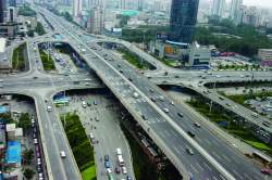
3. BEIJING: CAR
BEIJING HAS PURSUED A POLICY OF MASSIVE HIGHWAYS IN THE MIDDLE OF THE CITY. THE CHIEF PRODUCTS HAVE BEEN CONGESTION AND COARSENESS.
--
JAM
Building a massive road system in Beijing — even at a time when car ownership was rare – proved to be a self-fulfilling prophecy. The summary evictions and constructions of the ring road building in the 1980s were the prelude to the flash motorization that started in the mid ’90s. People were seduced into cars, but equally they were pushed. Extreme disruptions to the city fabric made by the new super-roads rendered alternatives increasingly impossible. Distances got bigger, and the urban environment markedly less friendly to bicycles, or pedestrians trying to cross a road to get to a bus or subway stop. Add to this the allure factor — the status attributed to car owners in China — and the result has been unequivocal: Beijing’s vehicle fleet doubled from 1 to 2 million in the years 1997 to 2003, topped 3 million in 2006, and
is expected to exceed 5 million well before 2020.
Road building however has not been able to keep pace. In spite of massive efforts, including a doubling of paved surface area in the post-reform period up to 1999, maintaining former car to road space ratios is simply not feasible. Nor is it desirable.
Inner city rings have consumed vast areas of downtown space, created stark divides between neighborhoods, and impacted severely upon air quality, not least in dense residential areas. Exhaust fumes account for over 50% of Beijing’s pollution, making it the world’s most polluted capital, with distinct corridors of dirty air hanging over the major routes. Respiratory issues are pandemic across the city, with lung cancer being the number one cause of death.
Costs to the city arising from congestion are equally alarming. Average vehicle speeds on the main streets of Beijing dropped to 12kmh in 2003, with lows of 7kmh, effectively throwing drivers back to biking speeds. Traffic affects the central ring roads for 13 out of 24 hours. This not only presents substantial direct losses in terms of fuel and man hours, but also degrades city accessibility. Places are often simply too arduous to get to. Professional and recreational decisions are restricted accordingly, leading to significant business losses.
From any position Beijing casts a pattern of blind spots – places too inaccessible to treat as regular destinations. One has to conclude in daily life most of the city is out of reach.
不管你在北京的哪里,城市都是有盲点的 - 总有一些地方不能轻而易举地到达.我们不能不承认,对于居民的日常生活来说,北京的大部分地方都是够不着的.
A key contributor to Beijing’s poor performance in terms of traffic is the city layout, which both historically and currently displays a tendency toward cellular structures, with marked schisms between large intercellular roads and small intracellular roads. hutongs*, communist dormitory compounds, blocks of dormitory extrusions*, gated communities, and the big office towers of the CBD and elsewhere all internalize large areas of road surface which are either closed off or unamenable to through traffic. Consequently, vehicles are all driven down a limited number of larger, more arterial roads. These tend to be two-way and multi-lane, with regular traffic knots at left turns and around compound exits and entrances. Crucially, these points of first contact with urban public space are gruesomely inhospitable. Most contemporary developments are either car orientated by design, or simply lack a competitive public transport option. Developers continue to break new ground in the suburbs without reference to a larger urban plan, and infrastructure is constantly playing catch up.
“The contradiction between real estate development and traffic regulations is the biggest problem now facing Beijing,”
— Wang Qishan, Mayor of Beijing (2004)
4. BEIJING: SOCIAL
INTRODUCTION OF MARKET REFORMS HAS FOCUSED ON URBAN DEVELOPMENT AS A MAJOR DRIVER OF ECONOMIC GROWTH. THE CHIEF PRODUCT HAS BEEN CRUDELY STRATIFIED CITY ISLANDS WHICH FAIL TO INTER-RELATE.
--
EXPANSION AND EXCLUSION
The uncompromising overwriting of dense areas of Beijing in order to instate the ring road system has had radical consequences for the urban texture. Flyovers and clover leafs drew apparently arbitrary lines across old neighborhoods, introducing sudden divisions, cutting off odd quadrangles, and isolating the pedestrian within unnavigable skeins of road. To connect the different patches, thousands of footbridges have been erected, and tunnels dug.
At the same time, individual building projects have ballooned in size, disbanding the notion of local neighborhoods. Social interaction and commercial services have been displaced outside the residential realm in pursuit of large-scale compounds for the new middle class. The concept of suburbia is offered at high-rise density and executed with blatant copy-paste efficiency. Large wall-like congregations of towers encircle a small communal space on top of a parking garage. These are the new building blocks of Beijing’s remarkably coarse urbanism. In the cases of Tian Tong Yuan and Wang Jing, single step developments accommodate populations approaching 500,000 people*.
Operating on such a scale, typological decisions rapidly define the masterplanning of an area. The new residential compounds act as single stamps, and yet their size makes them urban elements. They are inserted with minimum regard for circulatory ramifications or urban facilities, forming suburban bubbles within the downtown, and stark high-rise at the fringe. The sum of these Chinese stamps, loosely jostled among highways and leftover space, comes to define the city, reducing urban design to the practice of bloated architecture*.
The tendency of the stamps to be directed at single income brackets has also led to increasing social segregation. Expanding economic divisions within contemporary Chinese society find expression in fortified real estate projects, and while the introduction of a housing market has been a major growth driver toward the xiao kang* society, with it have come jagged housing inequalities. These are all the more striking when it is considered that communist standards of accommodation parity (at least among workers within individual danwei*, if not across the city or across the urban / rural divide) are for many within living memory.
For some old Beijingers housed within the more powerful danwei*, post-reform welfare structures have encouraged the purchase of their previously stateowned apartments. However for those drawn to the city by new opportunities and without the appropriate hukou*, the market is much less affordable. In addition to large scale estates for low to medium income inhabitants (such as Tian Tong Yuan and Wanjing), and the upmarket gated “plazas” of flashier towers or villas (and the top end of Beijing real estate has entered the global elite of super-exclusivity), at the bottom end, illegal and uncoordinated development is profuse. Migrant worker housing may be attached directly to specific construction sites. Equally it may develop informally in response to an official urban expansion project (as with Dong Xiao Kou*), or operate as a illegal suburb bubble in its own right (as with Zhejiangcun*).
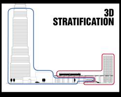
Often these different faces of stratified Beijing are spatially dislocated. Sometimes they are wedged cheek by jowl in crammed sub-centers, leading to bewildering juxtapositions of dilapidation, wealth density, and communist history. Within such contexts, new expensive multi-story compounds dissever themselves from the nearby lower buildings by height and access ways, leading to a 3-D stratification effect*. The various strata correlate directly to a particular relationship with public space, whereby basement shanty-towners rely on their feet, commieblock residents traipse to the subway and back, and inhabitants of gated communities are permanently shielded from the urban realm by the windscreens of their cars.
For the time being Beijing’s famously over-heated real estate market shows little sign of cooling. With apartment prices continuing to rise at 20–30% per year (well in excess of stagnant wage growth), the haves are not only maintaining their distance from the have-nots — they are in fact pulling ever further away. This accelerating economic disaggregation is another, this time socio-economic, aspect of exploding Beijing.
THE OFFICIAL RESPONSE
AT THE HEART OF ALL PLANNING STRATEGIES HAVE BEEN TWO GOALS: ENCOURAGE GROWTH — CURB CONGESTION. THESE CONTINUE TO DOMINATE CURRENT PROPOSALS, EVEN THOUGH METHODS HAVE CONSISTENTLY PROVED TO BE AT ODDS WITH RESULTS.
--
BEIJING 2020 — MASTERPLAN
In 2004, the Beijing Municipal Commission of Urban Planning produced the revision to the 1993 Beijing Master Plan for the year 2020. The objective was to create new guidelines to accommodate the city’s unprecedented expansion and tackle inefficiencies that had accumulated since the introduction of market reforms. Confronted by a city that seemed to be growing recklessly and even randomly, the first comprehensive plan for Beijing — including elements aimed to respond to market (and market-like) urbanizing forces — was formulated. The result was the “Beijing Spatial Development Strategy”. Further tweaking has yielded the contemporary planning proposals, which are focused
on three key points.
1. High intensity development is to be promoted eastwards toward the metropolis of Tianjin, and, as an environmental counterbalance, low intensity development is to progress westwards toward the mountains. This forms the structure for the “Two Axes Two Corridors — Multicenters” plan. By this, Beijing aims to retain its traditional north-south and east-west axes, and gain two corridors on either side of the center (running north-east to south-east, and north-west to south-west), which focus development, connect up and strengthen outlying polycenters, and thus relieve congestion in the downtown area. The Eastern Development Corridor is to be a dense straight of highly urbanized land incorporating both residential and business program along an arc of new satellite cities. The Western Development Corridor is to remain low density, with a focus on high-tech, eco-industry, culture, entertainment and leisure.
2. Designated cultural, historic, and environmental sites and open spaces are to be protected from (further) urban development.
3. The principle of “develop transportation infrastructure first” is to guide planning, and land development is to be confined within the capacity of
the transportation system. Development of transportation infrastructure is focused on three modes:
i. A massively upgraded road network, encompassing country roads, village streets, linkage routes, and expressways. The explicit aim is to bring node to center trips down to a one hour drive. Expressways are to be built connecting every suburban district and country center to the central downtown area, and linkage routes are to run from subordinate towns to country centers. ii. An extensive subway and light rail network. 20 lines comprising 561km of track are to be up and running by 2015 (from 4 lines of 142km in 2007). iii. An improved and diversified bus service. The wide reaching “Bus Service for Every Village Project” is to be continued, ensuring comprehensive bus services for all urban and rural residents of the Beijing area. Within the city proper, the Bus Rapid Transit System (BRT) will serve to reduce traffic by addressing the positioning of congestive bus stops. The BRT will be assisted by a centralized intelligent taxi data system, which will serve to minimize the number of empty cab journeys.
REALITY CHECK
CONTEMPORARY APPROACHES CONTINUE TO EXPRESS THE SAME ESSENTIAL CONTRADICTIONS: DECONGEST THE CENTER BY ENFORCING LONGER TRIPS; STAUNCH MOTORIZATION BY FEEDING IT MORE ROADS. THE PLANS MOVE OUT PEOPLE WHO DON’T HAVE CARS, BUILD BIGGER BLOCKS AT BIGGER DISTANCES, AND EXPECT PUBLIC TRANSPORT TO SOLVE COMMUTING. THIS WILL NOT PROVE EFFECTIVE. THE ILLUSIONS DRAWN UP WILL HIT A HARD REALITY IN THE FORM OF INACCESSIBILITY: THE ESSENTIAL PHENOMENON WHICH CHARACTERIZES MODERN BEIJING.
--
WHILE BEIJING IS ADVERTISING ONE FUTURE, CURRENT REALITIES ARE STRAINING IN ANOTHER DIRECTION. THE HISTORY OF BEIJING PLANNING / REALITY MISMATCHES IS ONE OF ACTUAL GROWTH CONSISTENTLY OUTPACING NOT ONLY PLANS, BUT THE RATE AT WHICH
THOSE PLANS ARE BEING DRAWN. PROJECTIONS ARE OUTDATED ON RELEASE AND LOOK LIKE OLD MAPS. PLANNING IS REDUCED TO POSTPLANNING: A MIXURE OF WISTFUL THOUGHTS AND POLITICAL PROPAGANDA.
DISPARITIES BETWEEN BEIJING AS A SUBJECT FOR URBAN DESIGN AND BEIJING AS A RAPIDLY EXPANDING MEGACITY ARE EXACERBATED BY THE PRIORITIZING OF ECONOMIC GROWTH (OFTEN REAL ESTATE DRIVEN) OVER DESIGN OBJECTIVES; THE INFORMALITY AND OBSCURITY SURROUNDING EACH AND EVERY INDIVIDUAL DEAL BETWEEN PRIVATE DEVELOPERS AND LOCAL OFFICIALS; AND THE
LARGE, EXTREMELY ACTIVE, AND CONSISTENTLY IGNORED INFORMAL POPULATION. THUS THE CHIEF AGENTS OF SPATIAL PRODUCTION
ARE DISENGAGED FROM CITY-WIDE PLANNING PROCESSES, WHILE PLANNERS THEMSELVES REFUTE THE MUD* PROCESSES BY WHICH DEVELOPMENT IS ACTUALLY OCCURRING.
AS MUD* CONTINUES TO ADD MATTER TO THE REAL BEIJING, A FAKE BEIJING IS EQUALLY UNDER PRODUCTION. FAKE BEIJING 2008 IS A GLOBALLY MARKETED CITY. IT CONSISTS OF A LIMITED NUMBER OF STARCHITECT BUILDINGS (“BEIJING IS MODERN”), UNESCO WORLD HERITAGE SITES (“HISTORICAL SEAT OF IMPERIAL POWER”), AND THE VERDURE WALLING OF INFRASTRUCTURE (”GREEN CITY, SUSTAINABLE CITY”). IT IS LENT FURTHER SUPPORT BY VIRTUAL BEIJING 2020 — A CITY WHICH EXISTS ENTIRELY ON HARD DRIVES, AND IS VISITED VIA CGI FLYTHROUGHS OF IMPECCABLY METROPOLITAN DISTRICTS (GLASS WRAPS, STEEL DIAGONALS, ELECTRONIC MUSIC ETC.). FAKE BEIJING BRANDS ITSELF FOR FOREIGN INVESTORS, FOR TOURISTS, AND FOR ITS OWN POPULATION — PLACATING UNREST WITH THE PROMISE OF AN ENTIRELY NEW CITY — A NEW FUTURE — LYING JUST BEYOND TOMORROW.
BUT FAKE BEIJING IS ENGAGED IN A CONSTANT AND EXPENSIVE PROCESS OF SAVING FACE. IT DEMANDS ENORMOUS CASH INJECTIONS
FOR ITS HUBRISTIC MEGAPROJECTS (THE OLYMPIC STADIA, CCTV, THE NATIONAL GRAND THEATER ETC.). SHABBY AREAS ARE PUSHED OUTWARDS. ENORMOUS VOLUMES OF WATER ARE DRAWN IN FROM OUTLYING CATCHMENT AREAS AND DISTANT DIVERTED RIVERS
TO MAINTAIN THE THEATRE SCREEN OF LUSHNESS. 30 YEAR OLD TREES ARE TRUCKED IN, STOOD UPRIGHT, AND CONNECTED UP TO
AN AUTOMATIC HOSE ...
CLEARLY THIS IS NOT A MODEL OF SUSTAINABILITY. TISSUE BETWEEN THE GLOBAL MEGAPROJECTS IS BECOMING COARSER AND
HARSHER, AND THE WATER TABLE (NOW 90% CONTAMINATED) IS AT AN ALL TIME LOW. FAKE BEIJING PREENS ITSELF IN THE MIRROR
AND WAITS FOR THE OLYMPICS. ALL THE WHILE, REAL BEJING IS SUBJECTED TO SPLINTERING FORCES.
Top-down megaprojects periodically push small informal developments further out to the periphery.
自上而下的巨型项目和大量中等规模的房地产项目则不断将小规模的自发性开发推向边缘地带.
REALITY CHECK I: MAPPING GROWTH
HISTORY REVEALS THE TOTAL INEFFICACY OF ALL PLANS TO DATE, AND THE SIMPLER TRUTH OF UNCONTROLLED UNCOORDINATED EXPANSION, AMONGST WHICH THE FAILURES OF SATELLITES AND GREEN BELTS ARE CASE IN POINT. PLANNING MEASURES HAVE IN FACT SERVED ONLY TO AGRAVATE THIS PROCESS.
POPULATION — obscuring milions
-INITIAL PERIOD OF RAPID EXPANSION
1949–1957.... ...First period of Sino-Soviet planning for Beijing’s population. Boundaries are redrawn and population limits set.
1957.................Limits exceeded
1958–1965..... ..3 new plans developed aimed to restrict population to between 5 and 6 million
1959.................Real population 7.2 million (up from 2.7 million in 1953)
-CONTINUING RAPID EXPANSION
1992................ Growth plan indicating development strategy for Beijing metropolitan area through to 2010: population limit set at 11.6 million
1991–2001..........Real Population growth: 10.8–13.8 million Of the additional 3 million, roughly 70% can be accounted for by the influx of migrants
-CURRENT 2020 FORECASTS
2007................ Beijing Spatial Planning Strategy suggests a population of 16–18 million Analysis based on availability of water sets the limit at 18 million Estimates for population size in 2007 suggest the 18 million cap has already been surpassed.
“If 1.6 billion is used as the total national population in 2020, the method predicts a Beijing population of 26 million in 2020. If the floating population is included based on its current percentage of the total population, then the Beijing population will be between twenty-four and thirty million people by 2020.” – Chengri Ding, Yan Song & Knaap, G. ‘Growth Scenarios for Beijing 2020: Technical Report on Beijing’s 2020 Comprehensive Plan Revision Process’ Lincoln Institute of Land Policy (2005)
FOOTPRINT — planning the past
1950.................Area within the historic city walls defining the metropolitan footprint of Beijing: 62km2
1990................ Area of Beijing metropolitan area: 430km2 (c.7x)
1992 ................Growth plan indicating development strategy for Beijing metropolitan area to
2010................ released. Contemporary footprint already exceeds expected growth.
2000................ Footprint runs beyond 2010 proposal
1958.................Plan released including proposal for 40 new satellite towns around Beijing
1958–1978...... .24 satellite towns built covering 100km2 of land and housing almost 1 million people
1982..................Plans released promoting further satellites as a means to curb congestion 1992 Plans continue to pursue a decongestion-via-population-dispersion strategy. From the original 40 satellites, then 24 satellites, the focus is narrowed to 14 existing satellites. The expectation for 2010 is for these satellites to grow in population to 1.94 million (increasing population share from 14.8% to 22.7%1)
2007.................Contemporary plans acknowledge that of the 14 satellites only 3 (Shunyi, Tongzhou and Yizhuang) are investment-worthy. Nevertheless, the ‘Beijing Old City Transformation and Relocation Plan’ continues to propose relocating residents from within the Second Ring Road out to the satellites. 1 Chengri Ding, Yan Song & Knaap, G. ‘Growth Scenarios for Beijing 2020: Technical Report on the Beijing’s 2020 Comprehensive Plan Revision Process’ Lincoln Institute of Land Policy (2005) p.20
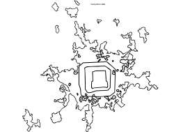
DESCRIBING GROWTH: THE SHAPE, DIRECTION &TEXTURE OF BEIJING’S DENSITY DYNAMICS
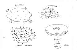
PANCAKE MODEL (SPREADING OUT)
IN SPITE OF REPEATED EFFORTS TO CONTROL POPULATION AND FOOTPRINT GROWTH, BEIJING CONTINUES TO EXPAND. BEIJING’S MUD* FORMATION HAS BEEN OBSERVED BY FIELDS OUTSIDE OF URBANISM. ANALYSIS OF BEIJING USING GRAVITATIONAL, ECONOMIC, AND NUCLEAR MODELING YIELDS A SINGLE RESULT: BASIC UNIDIRECTIONAL OUTWARDS SPREADING. THIS PATTERN, WHICH SEEMS TO ELUDE PLANNERS, IS ONE MOST RESIDENTS OF BEIJING KNOW ALL TO WELL. THEY DESCRIBE THEIR CITY WITH ONE OF THE LOCAL SNACKS — THE TANDABING — OR BIG SPREADING PANCAKE. THE INFRASTRUCTURAL RINGING OF THE CITY IS SIMULTANEOUSLY PROOF AND CAUSE OF THIS PATTERN. IT ACKNOWLEDGES THE PANCAKE, SUPPORTS IT, AND ENABLES FURTHER PANCAKE-LIKE EXPANSION.
DONUT MODEL (HOLLOWING OUT)
PROTECTIONS COVER THE HISTORIC CENTER, CREATING A DEVELOPMENTAL HOLE. SIMULTANEOUSLY HIGH RISE FOR THE NEW MIDDLE CLASS FOOTS ITSELF ALONG EXISTING HIGHWAYS, CREATING AN EXPANDING RING OF NEW BUILD. SLICK ARCHITECTURE AND PRIVATIZED COMMUNAL SPACE LENDS THIS FORMATION A GLAZING OF MODERNIZED APPEAL.
RAISIN BREAD MODEL (EXPANDING)
THE CITY IS UPSCALING AS ARE ITS ELEMENTS: ITS ROADS, ITS BUILDINGS, ITS URBAN BLOCKS. BEIJING BECOMES A UNIVERSE IN WHICH EVERYTHING IS SIMULTANEOUSLY SWELLING. WITHIN THE EVER COARSENING TISSUE, POINTS BECOME MORE DISTANT FROM ONE ANOTHER, LIKE RAISINS IN A RISING LOAF.
COOKIE MODEL (FUSING TOGETHER)
FEAR OF THE BIG CITY HAS MOTIVATED POLITICIANS TO PROMOTE SMALLER SETTLEMENTS, AND DIVERT METROPOLITAN GROWTH INTO PERIPHERAL SATELLITE CITIES. BUT DOES SMALL EQUAL STABLE? LOCATED TOO OFTEN TOO FAR FROM THE CENTER TO PROVIDE AN ATTRACTIVE CONNECTION, MOST OF THE PLANNED SATELLITES HAVE FAILED. BUT SUCCESSFUL SATELLITES ARE AS MUCH A CAUSE FOR CONCERN. UNDER THE PRESSURES OF MASS MIGRATION AND SUPERHOT REAL ESTATE, DEVELOPMENTS ON CHEAP LAND NEAR THE
CENTRE SWELL FAST. FOLLOWING THE GRAVITATIONAL ANALOGY, EACH SATELLITE SUFFERS ITS OWN DENSITY DECAY ALONG THE FRINGE. INSTEAD OF MAKING DISCRETE SHAPES, THE SPREADING FRINGES TOUCH AND FUSE, LIKE COOKIES GROWING TOGETHER ON A BAKING TRAY.
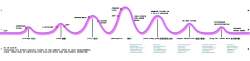
Counterintuitive curve: from the center outwards Beijing’s buildings get bigger; density drops
有悖直觉的曲线:从市中心向外,北京的建筑越来越高,密度却越来越低
REALITY CHECK II: MUD* DOMINATION
WHERE PLANNING HAS FAILED, MUD* HAS NOT.
--
A FAR CRY FROM THE VISION OF OFFICIAL PLANS, BEJING IS DOMINATED BY MUD*. MUD* DOES NOT RESPECT LIMITS. MUD* DOES NOT HOLD TO SATELLITE PLANNING. OVER THE LAST TEN YEARS THE CITY BEYOND THE FIFTH RING ROAD HAS EXPANDED MORE THAN 25%, COMPRISING A POPULATION OF 6 MILLION — A 40% SHARE OF THE ENTIRE CITY. MUD* HAS EATEN THROUGH THE FIRST PLANNED GREEN BELT AND STARTED ON THE SECOND. BY WORKING FASTEST AT THE FRINGE AND WITH NO IN BUILT REGARD FOR OVERALL CITY FORM, MUD* HAS CREATED A LARGE DISAGGREGATED URBAN MASS. APPLICATIONS OF PLANNING ARE PERFORMED AFTER THE FACT RATHER THAN IN ANTICIPATION OF THE FUTURE.
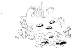
THE CONTEMPORARY POSTPLANNING RESPONSE TO MUD* IS MORE MULTICENTERS AND MORE INFRASTRUCTURE. THE TERM “MULTICENTERS” DEMONSTRATES AN UPDATE FROM “SATELLITES” — IT ACKNOWLEDGES AND AIMS TO ENCOMPASS THE LARGE DEVELOPMENTS WHICH HAVE BROKEN OUT ALONG THE BEIJING FRINGE. BUT STILL, IN ESSENCE, THE MULTICENTERS REPRESENT THE LONG MAINTAINED AND EVER UNSUCCESSFUL AMBITION TO DECONGEST THE CENTER BY MOVING PEOPLE OUT. THE INFRASTRUCTURAL COMPONENT IS NO MORE PROGRESSIVE. THE PROPOSAL FOR THE WORLD’S LARGEST SUBWAY NETWORK, IN COMBINATION WITH THE WORLD’S DENSEST INNER CITY RETICULATION OF HIGHWAYS, IRONICALLY PROMISES TO RENDER THE CITY OUT OF REACH TO MILLIONS OF ITS INHABITANTS. THE INEVITABLE PRODUCTS ARE MORE CONGESTION, MORE COARSENESS, AND LESS AMENITY. PLANNED STATIONS WILL BE INACCESSIBLE, AND THE TRAFFIC SITUATION WORSENED. LANDING AN INFRAHYBRID ON TOP OF EXPLODING BEIJING WILL NOT PROVE EFFECTIVE. IT FAILS TO ACKNOWLEDGE THE TEXTURE OF THE CITY IT INTENDS TO SERVE. THE PERIPHERY OF THE CITY WILL CONTINUE TO RUSH OUTWARDS, WHILE THE CENTER BECOMES EVER MORE DISRUPTED AND ATOMIZED.
Infrahybrid
Beijing’s stretched perimeter and planned infrastructure do not match up. The concentration of subway stations is in the center. Half the population lives in suburbs well beyond reach of this system.
INTEGRATED PLANNING ‑ DD
UNDERSTANDING AND WORKING WITH MUD* IS PARAMOUNT. AT THE CENTER OF MARKET FORCES IS THE MARKET NEED FOR ACCESSIBILITY. IT’S NOT A MARKET IF YOU CAN ONLY GET TO ONE STAND.
In spite of higher operating costs and logistical complexities, and often straight in the face of policy, cities continue to grow. The return benefit is growth of the labor market. The power of large labor markets offsets associated costs to such an extent that global megacities have risen in size, GDP and population to the point that their influence rivals that of their domicile nations. The disinclination of governments to accept the megacity is irrelevant in the face of its market power.
On these grounds the continuing expansion of Beijing — in particular expansion of the working population — can be regarded as more grist to its mill. However, the key to understanding the large labor market is that for it to provide the return — i.e. for the efficiency gains of the enlarged market to generate profits over and above the cost of the required additions to infrastructure and civic services — it must be unified. For the labor market to operate effectively, employers and employees within it must be able to compete with each other across the board. As soon as it becomes fragmented, and the fragments cease to compete, then further expansions present the city with costs, but no competitive gain. In effect, the new tissue is more expensive than it is worth. Preventing fragmentation of the labor market requires that it be mobile. Any job must be accessible to any worker from any part of the city.
Given market demands for mobility, it is unsurprising that MUD*-dominated expansion has clung to the monocentric core, and produced the tandabing (or pancake) rather than the planned satellites. Polycentric models with excessively specialized movement flows infringe upon the city’s ability to crossconnect. However, a single tighter layout which incorporates subcenters will allow some trip structuring, and yet preserve city-wide mobility. Larger cities tend to polycentrify, and as has been observed by Fengjian and Zhou Yixing2, during the post-reform era of rapid growth, Beijing has progressed from the monocentric city of the 1980s to a 1990s bi-nuclear city before becoming fully multi-nuclear in the 21st century.
The fastest growth in term of added built volume has been along the Fourth Ring Road. Initially development focused on the north-east side, catering to the influx of foreigners with high-end compounds. Today equally on the west and even in the south vast areas are being upgraded from dormitory blocks to lower-middle class dormitory extrusions*. This has created a clear ring of residential development. Simultaneously a top down stepping-stone offensive of large specialized districts backed by the central government has spurred the diversity and growth of this ring — most notably Zhongguancun, the CBD, Financial Street in the west, and the Olympic Village. These large-scale initiatives have been able to attract investment (as well as, particularly in the case of the Olympics, draw on enormous governmental slush funds) and boost employment, and by retaining proximity to the center, benefit from rather than disrupt the enormous reserve that is Beijing. Together these subcenters start to form a powerful new ring development.
If we respect the imperative to preserve Beijing’s historic center — in effect creating a hole — we see a new center developing around it: an urban donut connecting the different nodes of work, home and leisure.
accessibility considerations must factor in both travel time and travel distance
可达性=所耗时间+路程
TOWARD A PERICENTER
THE PERICENTER FOLLOWS NATURAL MUD* EXPRESSION. PLANNING EFFORTS SHOULD CONCENTRATE OPTIMIZING THIS EMERGENCE TOWARD AN EFFICIENT FUTURE FORM.
--
Dense concentrations within Beijing are not to be regarded as the problem but the solution. The mandate of the planner is to work with this imperative.
Under the communist system of state allocated jobs and housing, the two were necessarily unified, but bureaucratically mismanaged. By far the greater proportion of the world has now adopted a free-market approach, apportioning the responsibility for living and working choices largely to the individual. There is no city in existence to suggest that under such conditions of relative free movement, people won’t move freely in all directions: i.e. that residents will pay any attention to planning hopes for independent selfcontained elements within a larger urban framework. To quote Bertaud: ‘the utopian concept of a polycentric city as a cluster of urban villages persists [only] in the minds of planners.’
In the real world, satellite-driven polycentrification leads inevitably to fragmentation, granulation, and disintegration, which in China comes with coarser urban fabric and outbreaks of monosprawl*, infrasprawl* et al. Random commutes persist, only in an ever more congested context. On the other hand, real world economic clustering has proved highly desirable. Natural concentrations of growth which remain within an integrated context form the basic structure for metropolis building. Beijing, with the developments along the Fourth Ring Road, is moving toward this inherent shape. Yet the transition is not without risk.
It is important to guard against excessive specialization of districts, or to allow areas to become dominated by giant buildings positioned within massive set-backs serviced exclusively via large roads. Maintaining pan-directional ease of movement is key, with density being a vital part of any successful public transport system. To keep Beijing’s latent ring of subcenters fully accessible, and to curb the motorization-congestion tendency, it is necessary to transform it into a pedestrian orientated zone. Making the area where most people live, work, and travel also one which they walk through will ensure mixed and diverse programming, and a lively and naturally safer environment.
THE PERICENTER – A DD PROPOSAL
DENSITY ZONING STREAMLINES THE SHAPE OF THE CITY. DYNAMIC GROWTH TAKES PLACE BETWEEN THE THIRD AND FIFTH RING ROADS. HIGH-SPEED PEDESTRIAN-ORIENTATED INFRASTRUCTURE SERVICES THE NEW TISSUE. THE PERICENTER BECOMES A THRIVING CORRIDOR OF DIVERSE URBAN ACTIVITY, ABSORBING COMMUTES, AND CONSOLIDATING PUBLIC SPACE. THE STREETSCAPE IS REVIVED AS THE CITY’S TRUE URBAN INTERFACE.
--
DD analysis of Beijing proposes refocusing development on the zone where MUD* is already most active — i.e. between the Third and Fifth Ring Roads. The existing booming subcenters should be integrated within a continuous new center: the pericenter. This will offer the requisite space for growth within the current urban footprint. At present the density curve flattens across this zone. By raising pericenter densities to inner ring levels, it will be possible to accommodate a Beijing population of 20 million inhabitants without further pancake-like spreading.
Providing space for residents and migrants within the city proper and successfully integrating the floating population will be key to controlling sprawl formations in the outlying areas of Beijing. Furthermore, pericenter development will alleviate congestion within the historic center by increasing the number of destinations located in the subcenter belt. Commuters will be absorbed into the pericenter, and through-traffic rerouted along it.
The fact that the pericenter adheres closely to the current market-driven patterns makes it far less radical than the proposed satellite towns. It promises to form a unified coherent structure incorporating both top down and bottom up developmental forces in the territories where they already operate. Officially driven ventures, public-private collaborations, and low level entrepreneurial activities are all integral. The outwards creep of residential megablocks can be capitalized upon to create a clearly defined ring of high density. Recent developments such as Tian Tong Yuan literally stop on a line of twenty story towers. Here the urban fringe is in fact a wall. This can be used as an extremely effective city edge — inspiring growth to infill the pericenter rather than pursuing more distant developments of diminishing density.
Shifting developmental pressure away from the geographic center has an important historical precedent. In the early years of the PRC visionary planner Liang Sicheng, foreseeing the impending conflict between the narrow streets of Beijing and modern traffic practices, proposed moving the adminis- trative center west and preserving the historic city core. Guided by Soviet proposals, which stressed the propaganda potential of Tiananmen Square, the CCP rejected the plans, and blacklisted Sicheng. The plans have since been recirculated and discussed in different forms.
Relocating public buildings (of which there are over 400 in Beijing) to the pericenter will have two major impacts. Firstly, as trips related to official business account for a large proportion of single to low occupancy vehicles, the move will pull a major traffic contributor out of the center. Secondly, as governmental buildings can be forcibly repositioned to a fully planned location, they can be used to seed underdeveloped parts of the pericenter and drive up land values, thus incentivizing a market response. This forms the basis for the birch theory: significant hardy trees are planted in a degraded area to create the habitat within which other flora can then grow. Engendering flows of people and money fosters the creation of interprogrammatic mix among the specialized nodes. The pericenter should not be composed just of social housing and business districts, but be fully diverse, and appeal to the tourist, the shopper, and the general user.
The pericenter is to be promoted through two mechanisms:
1. To create a future-orientated compact plan, DD proposes a series of zones. These provide clear boundaries, with recommended densities and typologies suitable for different areas within the urban footprint. The zones act as a framework for steering future-proofed development while still apportioning considerable free reign to market players.
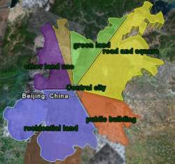
BEIJING ZONES
BLACK HOLE* - HISTORIC CORE
PERICENTER* – The New Dynamic Center of Beijing
GREEN EDGE* – The Green Edge is the area beyond the pericenter but within
the public transport footprint. It aims to offer a green moderately dense
environment.
FIELD OF GRAVITY* – Beijing’S functional urban region
2. The pericenter’s true dynamic quality is to come from a fully integrated pedestrian-orientated high-speed public transport system. This will run in a loop through the pericenter to form a zone-backbone. By connecting the pericenter up to itself, a clear locality is given, encouraging both physical development and an enhanced a sense of place. As higher densities and ease of access cluster along the ring, a new identity is formed — that of a modern city center wrapped around the historic core. Beyond the pericenter buses will continue to dominate public transport (predictions for Beijing’s future suggest that as much as 80% of trips in 2020 will be bus dependent). This is the greenest and most cost effective solution for the greater municipal area of Beijing given the bus’ low vehicle to passenger weight ratio, and continuous flexibility of route planning. The pericenter will defuse the scenario of severe bus congestion in a single central location by spreading the focus of numerous bus routes from a vast region along the whole of its length. Buses coming into Beijing from the Green Edge* and more distant nodes within the field of gravity will be assimilated into the pericenter at the nearest point. Further trip processing will be run through the pericenter, and only trips with destinations inside the historic core will need to enter. Pericenter transport will be focused on the D-Rail: a maglev-travelator hybrid that renders the entire pericenter accessible to foot traffic.
The pericenter retains a Modernist trust in density. Beijing must grow upwards as much as outwards. But unlike the Modernist city Beijing must also trust its dynamism. Recent history has proved that static instant solutions are outpaced by ongoing aggressive development. We can only assume this will continue. MUD* reveals the insuperable urge for outwards expansion. For the course of Beijing’s future development DD prescribes further densification, and a reinforcement of the center of urban gravity. The patchwork of micro-planing is replaced by the more abstract goal of the continued market-driven development of the pericenter and the Green Edge. Compressing function within these areas recreates pedestrian distances, and nurtures a human scale among the towers.
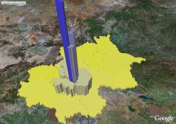
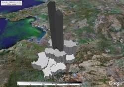
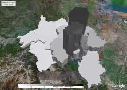
Follow up proposals: Wild Beijing
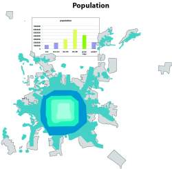
Population density - 3D graph within each ring road Crumbling Beijing
Population density goal for officially planned satellites Beijing 2020
total population - 3D graphs Beijing per district for GE
population density - 3D graphs Beijing per district for GE
working population - 3D graphs Beijing per district for GE
population density day-night

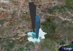
employment - 3D graphs Beijing per district for GE
average wage - 3D graphs Beijing per district for GE
immigrants - 3D graphs Beijing per district for GE
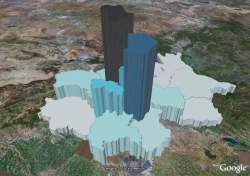
COMBINATION DOOM-DREAM:
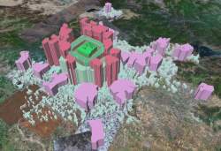
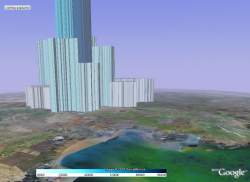
This is a comparison of 10-story building needed and to be provided in each ring 2020

Comparison of 10-story building needed and available in each ring
excel files about density
excel file about population
Up-scaling* - hutong to hyper-building*.

FOLLOWING: D-rail design and argument
Wang Jing
- Population
- Resident population: 147 000
- Floating population: 56 000
- Amount: 203 000
- Population measurement will be over 350 000 in 2020. In the future 10-15 years Populaton measurement will reach 600 000.
- 203000 people live in wangjing now. Mostly are young people with high eucation high income and strong consuming ability.
- Town planning
- Business area about 200 000 square meter. In cluding 33% community service; 28% of buliding materials center; 24% of super market; only 10% department store.
- Rent house
- Usually for rent an apartment in Wangjing as following:
- House 80-90m2 two rooms about 4000-5000rmb/month
- House 140-150m2 three rooms about 6000-8000rmb/month
- Buy house
- Average price in wangjing is 6000-8000yuan/m2
- Second hand house around 4600-5200yuan/m2
- Area coverage
- 13.84km2
- north to north fivth ring
- south to north fouth ring
- west reach Jingcheng expressway
- east to Jingshun expressway
- Travel
- In the morning 7:00-8:00AM
- In the evening 17:00-19:00 PM
- Density
- 68m2/per person
- 14500person/Km2
TianTongYuan
- Population
- About 300000 people living in TianTongYuan
- Town planning
- TTY becoming a huge residential zone with 300000 people
- There are many one-way street around TianTongYuan
- Rent house
- House 80-90m2 1200RMB/month
- House 140-150m2 3000RMB/month
- Buy house
- Average price in Tiantongyuan is 4000-6000RMB/m2
- Area coverage
- North to Taipingzhuang north road
- South to subway line 13
- West reach Beiyuan weat
- East to Beiyuan east road
- TTY area is 14km2
- Travel
- In the morning 7:00-8:00AM
- In the evening 18:00-20:00PM
- Density
- 47m2/per person
- 21429person/Km2
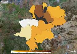
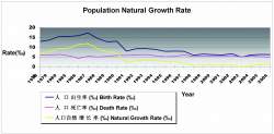
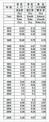
Population Natural Growth Rate
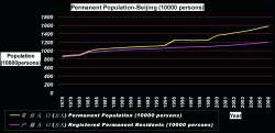
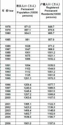
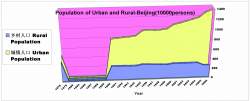
Permanent Population-Beijing
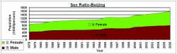
Sex Ratio-Beijing
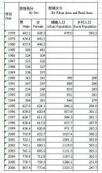
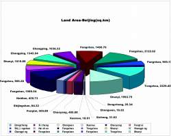
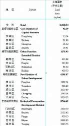
Land Area-Beijing
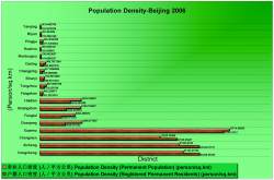
Population Density-Beijing2006
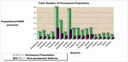
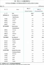
Total Number of Permanent Population
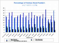
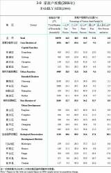
Percentage of Various Sized Family
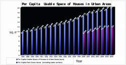
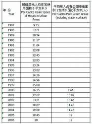
Per Capita Usable Space of Houses in Urban Areas
Owned by neville mars / Added by Stephanie Yao / 17.8 years ago / 85279 hits / 3 hours view time
Tags
Latest Entries
Contribute
Login to post an entry to this node.