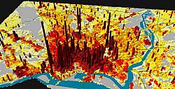
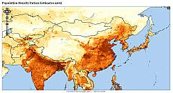
population density
LandScan™
The LandScan dataset estimates “ambient” population density — where people are likely to be at noon. LandScan pixels are 30 arc-seconds (or about 1 km wide at the equator). LandScan is updated every year on a one-year lag (thus, LandScan 2008 is available now).
To create LandScan, census counts (usually at sub-national level) were distributed to 30" by 30" grid cells using interpolation based on composite probability coefficients. The composite probability coefficients are relative likelihood of population existence in cells due to road proximity, slope, land cover, and nighttime lights (Dobson et al. 2000).
Roads -- weighted by distance from major roads.
Slope -- weighted by the favorability of slope categories.
Land Cover -- weighted by type, with exclusions for certain types.
Nighttime Lights -- weighted by frequency.
The resulting coefficients are weighted values, independent of census data, which can then be used to apportion shares of actual population counts within any particular area of interest. Coefficients vary considerably from country to country even within a particular region. Control totals can be based on any administrative unit (nation, province, district, minor civil division) or arbitrary polygon for which census data are available. The resulting population distribution is normalized and compared with appropriate control totals to ensure that aggregate distributions are consistent with census control totals.
http://www.ornl.gov/sci/landscan/index.shtml
Gridded population of the world
The CIESIN GPW dataset estimates residential population density — where people live and are likely to be at night. GPW pixels are 2.5 arc-minutes, or 5x bigger than the LandScan pixels. GPW is updated every five year
http://sedac.ciesin.columbia.edu/gpw/


